Showing posts with label Disease. Show all posts

Friday, September 27, 2024

Genomic profiling and spatial SEIR modeling of COVID-19 transmission

Lineage distribution of SARS-CoV-2 across
geographic regions of Ontario, Canada,
Western New York, and New York City over time
In the past we have posted on using agent-based models for explore the spread of diseases. We have been keeping up with this work especially in light of COVID-19. To this end we are excited to introduce our new paper entitled "Genomic Profiling and Spatial SEIR Modeling of COVID-19 Transmission in Western New York" published in Frontiers in Microbiology"  In this paper have been collaborating with other researchers at the University at Buffalo who focus  on the genomic sequencing of various lineages distribution of SARS-CoV-2. What is special about this  new paper is that we explore how such linages change over space and time and how this relates to movement patterns. If this sounds of interest, below you can read the abstract of the paper, see some the lineages in different regions which change over space and time, and our agent-based model which explores how different lineages might spread though peoples movement patterns. At the bottom of the post, you can see the full reference and the link to the paper itself.  

Abstract: 

The COVID-19 pandemic has prompted an unprecedented global effort to understand and mitigate the spread of the SARS-CoV-2 virus. In this study, we present a comprehensive analysis of COVID-19 in Western New York (WNY), integrating individual patient-level genomic sequencing data with a spatially informed agent-based disease Susceptible-Exposed-Infectious-Recovered (SEIR) computational model. The integration of genomic and spatial data enables a multi-faceted exploration of the factors influencing the transmission patterns of COVID-19, including genetic variations in the viral genomes, population density, and movement dynamics in New York State (NYS). Our genomic analyses provide insights into the genetic heterogeneity of SARS-CoV-2 within a single lineage, at region-specific resolutions, while our population analyses provide models for SARS-CoV-2 lineage transmission. Together, our findings shed light on localized dynamics of the pandemic, revealing potential cross-county transmission networks. This interdisciplinary approach, bridging genomics and spatial modeling, contributes to a more comprehensive understanding of COVID-19 dynamics. The results of this study have implications for future public health strategies, including guiding targeted interventions and resource allocations to control the spread of similar viruses.
Phylogenetic and spatial–temporal distribution of omicron BA.2.12.1. (A) Geographic introduction and organization of BA.2.12.1 lineage from February 2022 to November 2022, by percentage of SARS-CoV-2 circulating in each county per month. N/A represents counties with no BA.2.12.1 cases sequenced. (B) Phylogenetic clustering of jukes-cantor distance estimations between consensus sequences of 2,737 samples. Lineages on the phylogenetic tree are color-coded by county; Erie County (pink), Monroe County (green), Onondaga County (blue), and Westchester County (chartreuse). (C) Hierarchical clustering of sample-to-sample distance estimation of 2,737 BA.2.12.1 lineages in four counties across NYS, with k-means clustering k = 4.
SEIR model schematic and dynamics. (A) Schematics of SEIR model including general parameter and synthetic population parameter sets, and model initialization and function (B) R0 = 3 Susceptibility, Exposed, Infectious, and Recovered curves based on the introduction of two infected agents, monitored over time. (C) R0 = 5, (D) R0 = 8.
Commuter behavior dynamics in WNY. Estimated commuter populations originating in a specific county. (A) Commuter behavior with Erie County origins. (B) Commuter behavior from Niagara County origin. (C) Commuter behavior from Monroe County origin. (D) Composite Commuter behavior network.

Full Reference: 

Bard, J.E., Jiang, N., Emerson, J., Bartz, M., Lamb, N.A., Marzullo, B.J., Pohlman, A., Boccolucci, A., Nowak, N.J., Yergeau, D.A., Crooks, A.T. and Surtees, J. (2024), Genomic Profiling and Spatial SEIR Modeling of COVID-19 Transmission in Western New York, Frontiers in Microbiology, 15. Available at  https://doi.org/10.3389/fmicb.2024.1416580  (pdf)

Friday, November 03, 2023

Geographically Synthetic Populations for ABM: A Gallery of Applications

Often we are building geographically explicit agent-based models we spend a lot of time creating the synthetic population to instantiate our artificial world. We have tired to overcome this with creating methods to generate such populations (see this old blog post). Building on this work, Na (Richard) Jiang, Fuzhen Yin, Boyu Wang and myself have a new paper entitled "Geographically-Explicit Synthetic Populations for Agent-based Models: A Gallery of Applications" which was presented at 2023 Computational Social Science Society of the Americas conference. In the paper we extend the synthetic population to the whole of New York state. While at the same time we introduce a pipeline for using the population datasets for model initialization. To show this pipeline, we present several case studies utilizing Python and Mesa. These models range from that of commuting to disease spread and vaccination uptake. If this sounds of interest, below we provide the abstract to the paper along with some of the key figures including our pipeline and example applications. At the bottom of the page we provide the full reference and a link to the paper which has links to the models and data.
Abstract: Over the last two decades, there has been a growth in the applications of geographically-explicit agent-based models. One thing such models have in common is the creation of synthetic populations to initialize the artificial worlds in which the agents inhabit. One challenge such models face is that it is often difficult to create reusable geographically-explicit synthetic populations with social networks. In this paper, we introduce a Python based method that generates a reusable geographically-explicit synthetic population dataset along with its social networks. In addition, we present a pipeline for using the population datasets for model initialization. With this pipeline, multiple spatial and temporal scales of geographically-explicit agent-based models are presented focusing on Western New York. Such models not only demonstrate the utility of our synthetic population on commuting patterns but also how social networks can impact the simulation of disease spread and vaccination uptake. By doing so, this pipeline could benefit any modeler wishing to reuse synthetic populations with realistic geographic locations and social networks. 
Keywords: Agent-Based Model, Geographically-Explicit Agent-Based Models, Synthetic Population, Python, Mesa.
Pipeline of Utilizing Synthetic Population Resulting Datasets in Agent-Based Models.

Large Scale Disease Spread Model Structure.

Disease Dynamics for Two Diseases.

Vaccination Opinion Dynamic Model.

Simulation Vaccination Rate v.s. Real Vaccination Records: (A) All Population; (B) Different Age Groups of Population.

Full Referece: 

Jiang, N., Crooks, A.T., Yin, F. and Wang B. (2023), Geographically-Explicit Synthetic Populations for Agent-based Models: A Gallery of Applications, Proceedings of the 2023 Conference of The Computational Social Science Society of the Americas, Santa Fe, NM. (pdf)

Wednesday, March 22, 2023

AAG 2023 Presentations

At this years Association of American Geographers (AAG) Annual Meeting we have a number of presentations ranging from how one can leverage newspaper articles to study cities over time, to that of how people may chose to become vaccinated. These presentations build on the great work of students and postdocs here at the University at Buffalo and link to our interests in urban analytics, machine learning and agent-based modeling. Below we just give a glimpse at these topics (along with their abstracts) and if you are interested in finding out more please reach out to us.

First up is a presentation with Qingqing Chen and Boyu Wang entitled "Community resilience to wildfires: A network analysis approach utilizing human mobility data."  In this presentation we explore how we can quantify a communities resilience to wildfires utilizing human mobility through network analysis methods. 

Abstract 

Natural disasters, such as earthquakes, floods, and wildfires, have been a long-standing concern to societies at large. With growing attention being paid to sustainable and resilient communities, such concern has been brought to the forefront of resilience studies. However, the definition of disaster resilience is intricate and can vary across the diverse disciplines that study them (e.g., geography, sociology and political science), making its definition and quantification elusive. Moreover, the vast majority of studies often focus on the immediate response to an event, not the long-term recovery of the area impacted by disasters. Thus to date investigating the resilience of an area or a society over a prolonged period of time has remained largely unexplored. To overcome these issues, we propose a novel approach from a social perspective utilizing network analysis and concepts from disaster science (e.g., the resilience triangle) to quantify the long-term impacts of wildfires, especially on collective human behavior. Taking the Camp and Mendocino Complex wildfires - the most deadly and the largest complex wildfires in California to date, respectively - as case studies, we capture the features of resilience, such as robustness and vulnerability, of communities based on human mobility data from 2018 to 2020. The results show that demographic and socioeconomic characteristics alone only partially capture community resilience, however, by leveraging human mobility data and network analysis techniques, we can enhance our understanding of resilience over space and time, which can provide a new lens to study natural disasters and their long-term impacts on society.

Keywords: Community Resilience, Natural Disasters, Wildfires, Social Network Analysis, Human Mobility, Space and Time.

Full Reference

Chen, Q., Wang, B. and Crooks, A.T. (2023), Community Resilience to Wildfires: A Network Analysis Approach Utilizing Human Mobility Data, The Association of American Geographers (AAG) Annual Meeting, 23rd –27th March, Denver, CO. (pdf)

Next up, moving from mobility to textural data, specifically that of newspapers Na (Richard) Jiang and myself have a presentation entitled "Leveraging Newspapers to Understand Urban Issues: A Longitudinal Analysis of Urban Shrinkage in Detroit". In this work we explore how can leverage Bertopic (a topic modeling technique) on newspaper articles spanning the years 1975 to 2021 to explore urban shrinkage in Detroit. 


Abstract 

Today we are awash with data especially when it comes to studying cities from a diverse data ecosystem ranging from demographic to that of remotely sensed imagery and social media. This has led to the growth of geographical data science and urban analytics providing new ways to conduct quantitative research within cities. One area that has seen significant growth is that of using natural language processing techniques on text data from social media to explore various issues relating to urban morphology. However, social media only provides limited insights when dealing with longer-term urban phenomena, such as the growth and shrinkage of cities. This relates to the fact that social media is a relatively recent phenomenon compared to more longer-term urban problems that take decades to emerge. With respect to the longer-term coverage, newspapers which are increasingly becoming digitized provide the possibility to overcome the limitations of social media and provide insights over a timeframe that social media does not. To demonstrate the utilization of newspapers within urban analytics and to study longer-term urban issues, we present an advanced topic modeling technique (i.e., Bertopic) on a large number of newspaper articles spanning the years 1975 to 2021 to explore urban shrinkage in Detroit. Our topic modeling results reveal the insights related to Detroit's shrinkage can be linked to the side effects of economic recessions on Detroit's automobile industry, local employment status, and the housing market. As such, this work demonstrates the potential of utilizing newspaper articles to study long-term issues

Keywords: Natural Language Processing, Topic Modeling, Newspapers, Text Data, Urban Shrinkage, Urban Analytics. 

 Full Reference

Jiang, N., and Crooks A.T. (2023), Leveraging Newspapers to Understand Urban Issues: A Longitudinal Analysis of Urban Shrinkage in Detroit, The Association of American Geographers (AAG) Annual Meeting, 23rd –27th March, Denver, CO. (pdf)

Switching gears slightly, we have another presentation that leverages text data, in this case Yelp reviews to help inform decision making within an agent-based model. This presentation with Boyu Wang is entitled "Do people care about others' opinions of places? Utilizing crowdsourced data and deep learning to model peoples’ review patterns."  We use a geospatial artificial intelligence (GeoAI) technique called aspect-based sentiment analysis to extract and categorize reviewers' opinion aspects on places within urban areas and then use this information to inform an agent-based model of peoples choices to which restaurants to go to.


Abstract  

People's opinions are one of the defining factors that turn spaces into meaningful places. While these opinions are subject to individual differences, they can also be influenced by the opinions from others. Online platforms such as Yelp allow users to publish their reviews on businesses. To understand reviewers' opinion formation processes and the emergent patterns of published opinions, we utilize geospatial artificial intelligence (GeoAI) techniques especially that of aspect-based sentiment analysis methods (a deep learning approach) on a geographically explicit Yelp dataset to extract and categorize reviewers' opinion aspects on places within urban areas. Such data is then used as a basis to inform an agent-based model, where reviewers' (i.e., agents') opinions are characterized by opinion dynamics. The parameters of these models are calibrated using extracted opinion aspects from the Yelp dataset. Such a method moves opinion dynamics models away from theoretical concepts to a more data-driven approach, with a specific emphasis being made on place. Focusing on 10 US metropolitan areas which are spread out across the country, we examine the calibrated influence coefficients for each opinion aspect category (e.g., location, experience, service), to compare reviewers' opinion formation processes across different categories. The results show the emergent patterns of reviewers' opinions and the influence of these opinions on others. As such this work demonstrates how using deep learning techniques on geospatial data can help advance our understanding of place and cities more generally.

Keywords: Agent-Based Modeling, Crowdsourcing, Deep Learning, GeoAI, Opinion Dynamics, Urban Analytics

Full Reference

Wang, B. and Crooks, A.T. (2023), Do People Care About Others' Opinions of Places? Utilizing Crowdsourced Data and Deep Learning to Model Peoples’ Review Patterns, The Association of American Geographers (AAG) Annual Meeting, 23rd –27th March, Denver, CO. (pdf)
Following with the agent-based modeling theme, our final presentation with Fuzhen Yin and Li Yin is entitled "How Information Propagation in Physical, Relational and Cyber Spaces Affects Covid-19 Vaccine Uptake: Evidence from Rural Areas." In this work we explore how people may or not be influenced by others (in physical, relational and cyber spaces) with respect to vaccination uptake.


Abstract 
With the advent of information and communication technologies, human dynamics studied in a purely physical space increasingly shift to a cyber and relational context. While researchers increasingly recognize the shift and call for attention to the multi-dimensionality of human dynamics (e.g., Splatial framework). Rarely have studies investigated how the information propagated in hybrid spaces affects people’s decision-making process, such as Covid-19 vaccine uptake. Meanwhile, compared to the urban population, the rural population faces greater digital barriers and has been further left out in human dynamics research. To fill this gap, our study investigates Covid-19 vaccine uptake in a rural county (i.e., Chautauqua) in New York State through agent-based modeling. We first generated a synthetic population to match the demographic characteristics of the census data. Then we created home, work, school, and social media networks to represent hybrid spaces. We defined the opinion dynamics of agents based on the social influence network theory. Next, we calibrated and validated our agent-based model based on real-world vaccine update records. Our research helps to elucidate the information propagation mechanism in hybrid spaces and clarify the decision-making process in the digital age. Furthermore, our method can also shed light on how to overcome data limitations for under-represented populations such as those who live in rural areas.

Keywords: Agent-based modeling, Covid-19, Vaccination, Opinion dynamics, Urban informatics, Rural geography

Full Reference 
Yin, F., Crooks, A.T. and Yin, L. (2023), How Information Propagation in Physical, Relational and Cyber Spaces Affects Covid-19 Vaccine Uptake: Evidence from Rural County, The Association of American Geographers (AAG) Annual Meeting, 23rd –27th March, Denver, CO. (pdf)

Thursday, February 17, 2022

New Paper: Synthetic Populations with Social Networks

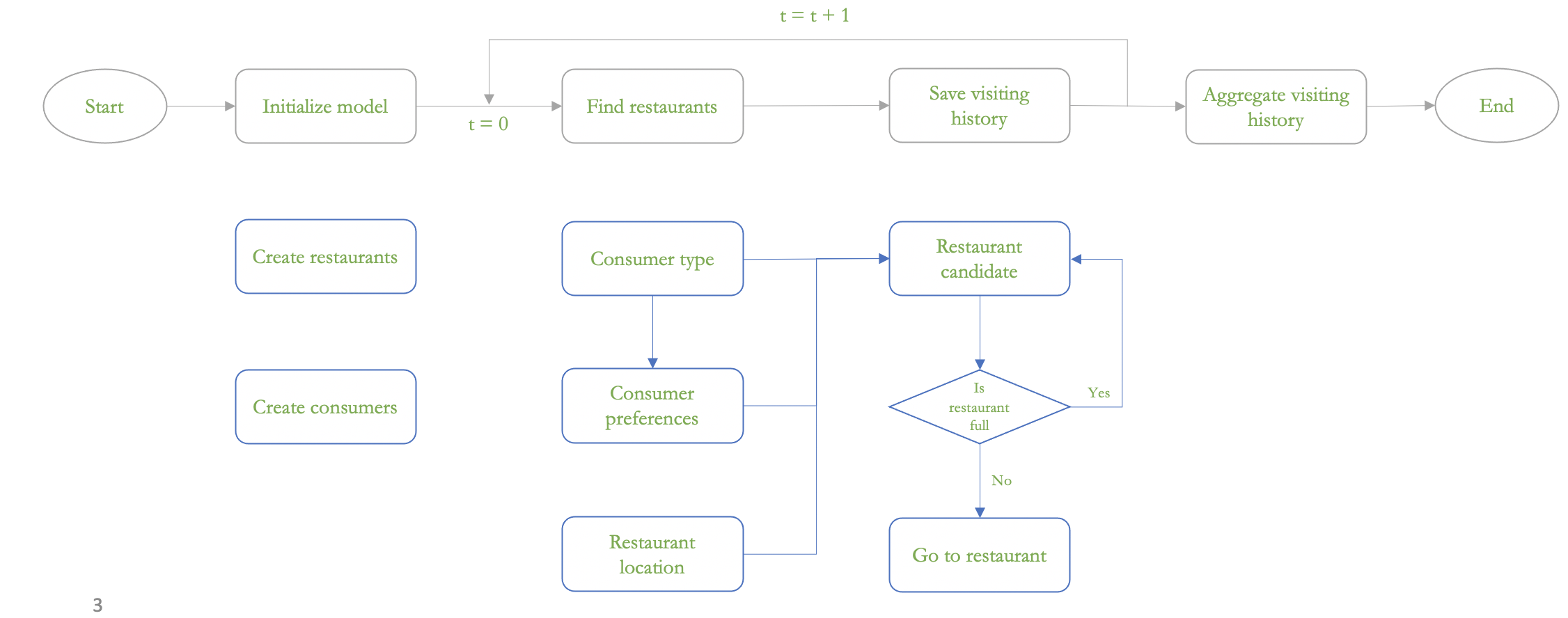
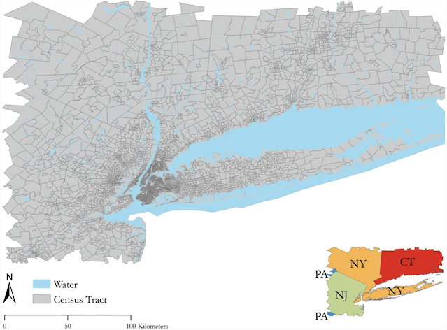
When developing geographically explicit agent-based models, one thing we spend a lot of time on is building synthetic populations and then linking the agents in the synthetic population to each other.  To overcome this issue we have a new paper published in "Computational Urban Science " entitled "A method to create a synthetic population with social networks for geographically-explicit agent-based models" In this paper  Na (Richard) Jiang, Hamdi Kavak, Annetta Burger, William Kennedy and myself present a synthetic population generation method that also includes social networks and use the New York Metro as a study site, which covers an area of 262 x 234 km and is home to over 23 million people. 

To show the utility of this method we also present three simple applications (e.g., a disease , a disaster  and a traffic model) which utilize different parts of this synthetic population but are all geographically explicit and use networks in some shape or form. If this sounds of interest, below you can read the abstract from the paper, along with seeing some of the figures from our methodology and example applications. While at the bottom of the post we provide the full citation and a link to the paper. The paper itself also has links to actual code that generates the synthetic population and the resulting datasets and models  (code: https://bit.ly/SynPopABM; source and resulting synthetic population data: https://osf.io/3vsaj/) .  

Abstract: 

Geographically-explicit simulations have become crucial in understanding cities and are playing an important role in urban science. One such approach is that of agent-based modeling which allows us to explore how agents interact with the environment and each other (e.g., social networks), and how through such interactions aggregate patterns emerge (e.g., disease outbreaks, traffic jams). While the use of agent-based modeling has grown, one challenge remains, that of creating realistic, geographically-explicit, synthetic populations which incorporate social networks. To address this challenge, this paper presents a novel method to create a synthetic population which incorporates social networks using the New York Metro Area as a test area. To demonstrate the generalizability of our synthetic population method and data to initialize models, three different types of agent-based models are introduced to explore a variety of urban problems: traffic, disaster response, and the spread of disease. These use cases not only demonstrate how our geographically-explicit synthetic population can be easily utilized for initializing agent populations which can explore a variety of urban problems, but also show how social networks can be integrated into such populations and large-scale simulations.

Keywords: Synthetic Population Generation, Agent-Based Modeling, New York, Traffic Dynamics, Disease, Disaster

Study Area

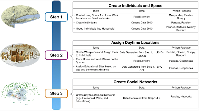
Workflow for Generation of Synthetic Population and Networks

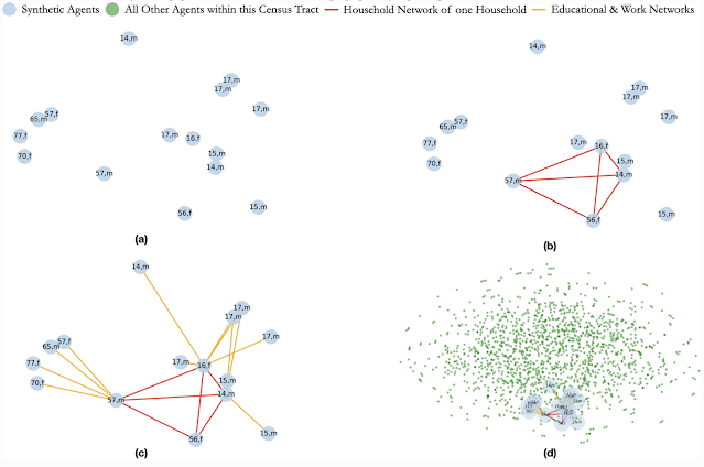
Creation of Social Networks: (a) Selected Population; (b) Creation of a Household Network; (c) Creation of Work and Educational Networks for each Member of the Household; (d) The Household, its Networks within the Full Census Tract

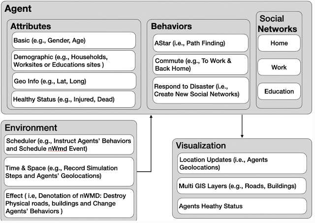
Model Component Structure of Population Respond to Disaster event

Agents’ Health Status After 1 Minute of the Disaster Event

Full Reference:

Jiang, N., Crooks, A.T., Kavak, H., Burger, A. and Kennedy, W.G. (2022), A Method to Create a Synthetic Population with Social Networks for Geographically Explicit Agent-Based Models, Computational Urban Science, 2:7. Available at https://doi.org/10.1007/s43762-022-00034-1

Thursday, December 02, 2021

Urban life: A model of people and places

We have just wrapped up project that created a simple agent-based simulation of urban life as part of DARPA's Ground Truth Program. To this end we have just published a  new paper entitled "Urban life: a model of people and places" published in Computational and Mathematical Organization Theory, with Andreas Züfle, Carola Wenk, Dieter Pfoser, Joon-Seok Kim, Hamdi Kavak, Umar Manzoor, Hyunjee Jin  and myself. In the paper we provide an overview of the model and how it was used to test and validate human domain research. For interested readers, below you can find the abstract  to the paper along with some images that will give you a sense of our simulation model (which for interested readers was created with MASON and its GIS extension (GeoMason). While at the bottom of the post you can find the full reference and a link to the paper. 

 Abstract

We introduce the Urban Life agent-based simulation used by the Ground Truth program to capture the innate needs of a human-like population and explore how such needs shape social constructs such as friendship and wealth. Urban Life is a spatially explicit model to explore how urban form impacts agents’ daily patterns of life. By meeting up at places agents form social networks, which in turn affect the places the agents visit. In our model, location and co-location affect all levels of decision making as agents prefer to visit nearby places. Co-location is necessary (but not sufficient) to connect agents in the social network. The Urban Life model was used in the Ground Truth program as a virtual world testbed to produce data in a setting in which the underlying ground truth was explicitly known. Data was provided to research teams to test and validate Human Domain research methods to an extent previously impossible. This paper summarizes our Urban Life model’s design and simulation along with a description of how it was used to test the ability of Human Domain research teams to predict future states and to prescribe changes to the simulation to achieve desired outcomes in our simulated world.

Our generated maps colored based on different aggregation levels.

A screenshot of the graphical user interface from a representative model run. Top-Left: The spatial network and agents. Bottom left: Simulation parameters that can be specified prior to simulation start. Top-middle: the social network. Bottom-middle: Summary statistics of the simulation during tun-time such as friendship. Right: Profiles of recreational sites.

Screenshot of the epidemic simulator depicting the French Quarter, New Orleans, LA, USA.

Full Reference:

Züfle, A., Wenk, C., Pfoser, D., Crooks, A.T., Kavak, H., Kim, J-S. and Jin, H. (2021), Urban Life: A Model of People and Places, Computational and Mathematical Organization Theory. Available at https://doi.org/10.1007/s10588-021-09348-7 (pdf)

Thursday, September 30, 2021

An Integrated Framework of Global Sensitivity Analysis and Calibration for Spatially Explicit ABMs

In the past we have written about the challenges of validation and to some extent the calibration of agent-based models but never really went into much detail about the calibration process. To this end, Jeon-Young Kang, Alexander Michels, Jared Aldstadt, Shaowen Wang and myself recently had a paper published in Transactions in GIS entitled "An Integrated Framework of Global Sensitivity Analysis and Calibration for Spatially Explicit Agent-Based Models." In the paper we have present an integrated framework for global sensitivity analysis and calibration (GSA-CAL), and then apply the framework to a spatially explicit agent-based model of influenza transmission as a case study in the city of Miami, FL. If this sounds of interest, below you can read the abstract to the paper, see some of the figures from the paper including the general workflow and some of the results. At the bottom of the post you can find the full citation and a link to the paper.

Abstract

Calibration of agent-based models (ABMs) is a major challenge due to the complex nature of the systems being modeled, the heterogeneous nature of geographical regions, the varying effects of model inputs on the outputs, and computational intensity. Nevertheless, ABMs need to be carefully tuned to achieve the desirable goal of simulating spatiotemporal phenomena of interest, and a well-calibrated model is expected to achieve an improved understanding of the phenomena. To address some of the above challenges, this article proposes an integrated framework of global sensitivity analysis (GSA) and calibration, called GSA-CAL. Specifically, variance-based GSA is applied to identify input parameters with less influence on differences between simulated outputs and observations. By dropping these less influential input parameters in the calibration process, this research reduces the computational intensity of calibration. Since GSA requires many simulation runs, due to ABMs' stochasticity, we leverage the high-performance computing power provided by the advanced cyberinfrastructure. A spatially explicit ABM of influenza transmission is used as the case study to demonstrate the utility of the framework. Leveraging GSA, we were able to exclude less influential parameters in the model calibration process and demonstrate the importance of revising local settings for an epidemic pattern in an outbreak.


Workflow of global sensitivity analysis and calibration

Study area

Daily activity-based contact network construction

Results from calibration distance-based mobility (DBM): (a) simulated results from an initial model; (b) simulated results from the calibrated model; and (c) sum of RMSE
 

Full Reference:

Kang, J-Y., Michels, A., Crooks, A.T., Aldstradt, J. and Wang, S. (2021), An Integrated Framework of Global Sensitivity Analysis and Calibration for Spatially Explicit Agent-Based Models, Transactions in GIS. https://doi.org/10.1111/tgis.12837 (pdf)

Wednesday, June 30, 2021

Towards Large-Scale Agent-Based Geospatial Simulation

Running large scale spatial agent-based models is often a computational challenge. To address this challenge, at the upcoming International Conference on Social Computing, Behavioral-Cultural Modeling and Prediction and Behavior Representation in Modeling and Simulation (or SBP-BRiMS for short), Umar Manzoor, Hamdi Kavak, Joon-Seok Kim, Dieter Pfoser, Andreas Zufle, and Carola Wenk and myself have a paper entitled "Towards Large-Scale Agent-Based Geospatial Simulation."

In the paper we propose a scalable and general agent-based modeling and simulation framework for geospatial simulations involving networks. Specifically we propose to a solution for the parallelization of the single-threaded GeoMASON tookit by employing the Java Agent Development Environment (JADE) for the communication between threads (essentially, we divide the space of our agents into partitions, each handled by a separate thread of execution). We evaluate the proposed framework an simple urban model (created in MASON), which simulates simple patterns of life within an urban setting (click here for the blog post). The model has spatial network for agent movement and social network for maintaining social links. We compared the performance of the proposed framework on different settings, and concluded from experimentation that the proposed framework is outperformed by GeoMason when the agent population is small whereas with an increasing agent population, our proposed framework outperforms GeoMason as the complexity and time taken in simulation step increases substantially. If this sounds of interest, below we provide the abstract to the paper, along with some images of the framework and and simulation architecture. At the bottom of the page you can find the full citation and a link to the paper.

Abstract. Agent-based geospatial simulations have become very popular and widely used in examining the social and cultural characteristics of populations. Well-known toolkits such as NetLogo or MASON generally have scalability limitations, especially when the model and underlying spatial infrastructure become complex. This paper presents a framework for simulating large-scale agent-based geospatial systems by integrating the multi-agent systems toolkit JADE with the MASON agent-based modeling framework and its GIS extension, GeoMASON. The proposed Java-based framework can simulate large areas with hundreds of thousands of agents. It allows for the studying the evolution of a population and its environment over time. Such a framework provides the essential first steps for scalable model execution without sacrificing the model generality. 

Keywords: Large-scale geospatial simulation, Agent-based Modeling, MASON, Jade, GIS.

System Architecture of Proposed Framework.
Agent transfer between Zones.
Simulation using Proposed Architecture.

Full Reference:

Manzoor, U., Kavak, H., Kim, J-S., Crooks, A.T., Pfoser, D., Zufle, A. and Wenk, C. (2021), Towards Large-Scale Agent-Based Geospatial Simulation, 2021 International Conference on Social Computing, Behavioral-Cultural Modeling and Prediction and Behavior Representation in Modeling and Simulation, Washington DC. (pdf)

Tuesday, June 02, 2020

Location-Based Social Simulation for Prescriptive Analytics of Disease Spread

Building upon our previous work on Location-Based Social Networks (LBSNs) and how agent-based modeling could provide an alternative to real world data sets, in the latest SIGSPATIAL Special Newsletter, we (Joon-Seok Kim, Hamdi Kavak, Chris Rouly, Hyunjee Jin, Dieter Pfoser, Carola Wenk, Andreas Zufle and myself) have an article entitled "Location-Based Social Simulation for Prescriptive Analytics of Disease Spread."

In this article we discuss a geographically explicit agent-based model that we have been developing that is capable not only of simulating human behavior but also able to create synthetic but realistic LBSN data based on human patterns-of-life. Furthermore, in the article we discuss how such data and models can be used to explore the parameter space of possible prescriptions to find optimal strategies (or policies) to achieve a desired system state and outcome. We refer to such a search for optimal policies as prescriptive analytics. (for readers wishing to learn more about prescriptive analytics please see the 1st ACM KDD Workshop on Prescriptive Analytics for the Physical World).

To give an example of such prescriptions, in the article we make use of a simple hypothetical disease model and explore two prescribed policies to mitigate the spread of the disease. The first policy requires all agents to wear simulated Personal Protective Equipment (PPE) that reduce the chance of infection by 50%. The second policy enforces strict social distancing measures onto a fixed proportion of 50% of the population. Those who follow the social distancing order avoid recreational site visits from meeting people although they still go to restaurants. In addition to these two policies, as a baseline, we also ran a “null-prescription” in which no intervention was prescribed. We find that the social distancing prescription was extremely effective. On the other hand, our simulation results for PPE policy showed that merely wearing protective gear without any change in behavior has no significant effect (for the case of this disease).

If this type of research is of interest to you, below we provide the abstract to the paper, a movie of a representative simulation run, some of our results of the prescriptions described above and a link to the paper itself. Further information about the model and data can be found at https://geosocial.joonseok.org/p/epidemic.html and the data is available at https://osf.io/e24th/. Also as we are currently going through COVID-19, we thought a a brief write up and links to some disease models and discussions of modeling efforts related to it was also appropriate to include.

Abstract: 
Human mobility and social networks have received considerable attention from researchers in recent years. What has been sorely missing is a comprehensive data set that not only addresses geometric movement patterns derived from trajectories, but also provides social networks and causal links as to why movement happens in the first place. To some extent, this challenge is addressed by studying location-based social networks (LBSNs). However, the scope of real-world LBSN data sets is constrained by privacy concerns, a lack of authoritative ground-truth, their sparsity, and small size. To overcome these issues we have infused a novel geographically explicit agent-based simulation framework to simulate human behavior and to create synthetic but realistic LBSN data based on human patterns-of-life (i.e., a geo-social simulation). Such data not only captures the location of users over time, but also their motivation, and interactions via temporal social networks. We have open sourced our framework and released a set of large data sets for the SIGSPATIAL community. In order to showcase the versatility of our simulation framework, we added disease a model that simulates an outbreak and allows us to test different policy measures such as implementing mandatory mask use and various social distancing measures. The produced data sets are massive and allow us to capture 100% of the (simulated) population over time without any data uncertainty, privacy-related concerns, or incompleteness. It allows researchers to see the (simulated) world through the lens of an omniscient entity having perfect data.

Screenshot of the epidemic simulator depicting the French Quarter, New Orleans, LA, USA.


New cases and SEIR epidemic course.


Full Reference:
Kim, J-S., Kavak, H., Rouly, C.O., Jin, H., Crooks, A.T., Pfoser, D., Wenk, C. and Zufle, A. (2020), Location-Based Social Simulation for Prescriptive Analytics of Disease Spread, SIGSPATIAL Special, 12(1): 53-61. (pdf)

The Washington Post's Disease Model
While this post is not about COVID per se, if you are interested in disease models the Washington Post had a great article about COVID several months ago entitled "Why outbreaks like corona virus spread exponentially, and how to “flatten the curve”." This article generated a lot of discussion such as on the SIMSOC Mailing list and was citied in a paper in the Journal of Artificial Societies and Social Simulation (JASSS) entitled  "Computational Models That Matter During a Global Pandemic Outbreak: A Call to Action." Other goods discussions on COVID related models (particularly agent-based models) can be found on Review of Artificial Societies and Social Simulation (RofASSS) website (here), the CoMSES Net Discourse Forum (along with links to past epidemic models) and the Sociology and Complexity Science Blog has some very good posts on modeling and public health.

Wednesday, July 18, 2018

Online Vaccination Discussion and Communities in Twitter

Continuing on our work of exploring health related issues in social media, Xiaoyi Yuan and myself had a paper accepted at the 9th International Conference on Social Media and Society. In our paper entitled: "Examining Online Vaccination Discussion and Communities in Twitter"  we examined the communication patterns of anti-vaccine and pro-vaccine users on Twitter by studying the retweet network from 660,892 tweets related to the measles, mumps, and rubella (MMR) vaccine published by 269,623 users using supervised learning to identify clusters of users based on their opinions (i.e. a pro-vaccine, anti-vaccine, or neutral user). 

The overall methodology can be seen in Figure 1 and more details can be found in the paper. Our data was collected using the GeoSocial Gauge System, however, since tweets are short and their content diverse, the data corpus needed to be cleaned so that the tweets could then be converted to features (e.g., unigrams or bigrams). After which we were able to use such features for training a variety of classifiers (i.e., logistic regression, support vector machine (linear and non-linear kernel), k-nearest neighbors, nearest centroid, and Naïve Bayes) to identify opinion groups. After this, we moved from on from identifying each user’s opinion to construct a retweet network in order to understand how in-group and cross-group communicate in the committees detected via retweet network. By carrying out this analysis we discovered that pro- and anti-vaccine users retweet predominantly from their own opinion group, while users with neutral opinions are distributed across communities. Below you can read our abstract, see some results from our study and the full reference (and link) to the paper.


Figure1: Steps used in our study to unveil the communication patterns of pro-vaccine and anti-vaccine users on Twitter
 Abstract:
Many states in the US allow a “belief exemption” for measles, mumps, and rubella (MMR) vaccines. People’s opinion on whether or not to take the vaccine could have direct consequences in public health— once the vaccine refusal of a group within a population is higher than what herd immunity can tolerate, a disease can transmit fast causing large scale of disease outbreaks. Social media has been one of the dominant communication channels for people to express their opinions of vaccination. Despite governmental organizations’ effects of disseminating information of vaccination benefits, anti-vaccine sentiment is still gaining its momentum, especially on social media. This research investigates the communicative patterns of anti-vaccine and pro-vaccine users on Twitter by studying the retweet network from 660,892 tweets related to MMR vaccine published by 269,623 users after the 2015 California Disneyland measles outbreak. Using supervised learning, we classified the users into anti-vaccination, neutral to vaccination, and pro-vaccination groups. Using a combination of opinion groups and retweet network structural community detection, we discovered that pro- and anti-vaccine users retweet predominantly from their own opinion group, while users with neutral opinions are distributed across communities. For most cross-group communication, it was found that pro-vaccination users were retweeting anti-vaccination users than vice-versa. The paper concludes that anti-vaccine Twitter users are highly clustered and enclosed communities, and this makes it difficult for health organizations to penetrate and counter opinionated information. We believe that this finding may be useful in developing strategies for health communication of vaccination and overcome some the limits of current strategies.

Key Words: Anti-vaccine movement, Twitter, social media, opinion classification
Figure 2: Network visualizations of the four largest communities. A: is colored by the belonging to a specific structural community and; B: is colored by belonging to opinion groups

Figure 3: Distributions of opinion groups in the four largest structural community

Full Reference:
Yuan, X. and Crooks, A.T. (2018), Examining Online Vaccination Discussion and Communities in Twitter, Proceedings of the 9th International Conference on Social Media and Society, Copenhagen, Denmark, pp 197-206. (pdf)

Update: Our paper was selected as best paper at the conference.


Friday, November 17, 2017

New Paper: Social Media and Cancer Campaigns

Continuing our work on geosocial analysis we recently had a paper entitled "Social Media Engagement with Cancer Awareness Campaigns Declined During the 2016 U.S. Presidential Election" published in  World Medical and Health Policy. In the paper we show through the analysis of Twitter and Google Trends, how public engagement with breast cancer and prostate cancer awareness months between 2015 and 2016 changed. Specifically we found that attention to breast cancer and prostate cancer declined in 2016 (during the U.S. presidential election), when compared to 2015. Based on our finding we suggest that future cancer education campaigns—and campaigns for other health issues and policies—would benefit from monitoring the broader issues producing social media engagement, and adjusting their timing or communication strategies to ensure that public engagement with their key messages remains strong even in a crowded social media marketplace. Below you can read the abstract to our paper, see some of our key findings along with the full citation to the paper.

Abstract:
Cancer awareness campaigns compete with other health and social issues for public attention. We examined whether public engagement with breast cancer and prostate cancer declined in 2016 during the U.S. presidential election compared to 2015 on Twitter and Google Trends. We found that attention to breast cancer and prostate cancer declined in 2016 before the election as compared to 2015 in Twitter posts and Google searches. The findings suggest that cancer information seeking behavior, passive exposure to health communication, and active participation in social media about cancer all decreased during the peak weeks of the 2016 election season. Future health promotion initiatives and information dissemination efforts will benefit from monitoring the major issues garnering social media attention and then adjusting their timing or communication strategies to ensure that public engagement with their key policy messages remains strong when emerging news stories capture public interest.

Keywords: Twitter; breast cancer; prostate cancer

Twitter Traffic about Breast Cancer (a) and Prostate Cancer (b) in the Period October 2015–November 2016, and Comparison of October and November Traffic in 2015 and 2016 for Breast Cancer (c) and Prostate Cancer (d). All 2015 Data are Shown in Red and All 2016 Data are Shown in Blue.


Full Reference:
Vraga, E. K., Radzikowski, J., Stefanidis, A., Croitoru, A., Crooks, A.T., Delamater, P., Pfoser, D. and Jacobsen, K. H. (2017). Social Media Engagement with Cancer Awareness Campaigns Declined During the 2016 U.S. Presidential Election. World Medical and Health Policy, 9(4): 456–465. (pdf)

Friday, June 30, 2017

From Cyber Space to Physical Space Disease Outbreaks


At the upcoming 2017 International Conference on Social Computing, Behavioral-Cultural Modeling and Prediction and Behavior Representation in Modeling and Simulation  conference (or SBP-BRiMS 2017 for short), Xiaoyi Yuan and myself will present a paper entitled: "From Cyber Space Opinion Leaders and the Diffusion of Anti-vaccine Extremism to Physical Space Disease Outbreaks". In the paper we explore how online discussions with respect to vaccinations can potentially impact on the spread of a disease. Below you can read the abstract to our paper, see the basic model logic and movie of a single simulation. If you are interested in finding out more about the model or running it yourself, you can do so here: https://www.openabm.org/model/5509/


Measles is one of the leading causes of death among young children. In many developed countries with high measles, mumps, and rubella (MMR) vaccine coverage, measles outbreaks still happen each year. Previous research has demonstrated that what underlies the paradox of high vaccination coverage and measles outbreaks is the ineffectiveness of “herd immunity”, which has the false assumption that people are mixing randomly and there’s equal distribution of vaccinated population. In reality, the unvaccinated population is often clustered instead of not equally distributed. Meanwhile, the Internet has been one of the dominant information sources to gain vaccination knowledge and thus has also been the locus of the “anti-vaccine movement”. In this paper, we propose an agent-based model that explores sentiment diffusion and how this process creates anti-vaccination opinion clusters that leads to larger scale disease outbreaks. The model separates cyber space (where information diffuses) and physical space (where both information diffuses and diseases transmit). The results show that cyber space anti-vaccine opinion leaders have such an influence on anti-vaccine sentiments diffusion in the information network that even if the model starts with the majority of the population being pro-vaccine, the degree of disease outbreaks increases significantly. 

Keywords: Agent-based modeling Information networks Infectious disease transmission.


Full Reference:  
Yuan, X. and Crooks, A.T. (2017), From Cyber Space Opinion Leaders and the Spread of Anti-Vaccine Extremism to Physical Space Disease Outbreaks, in Lee, D., Lin, Y., Osgood, N. and Thomson, R. (eds.) Proceedings of the 2017 International Conference on Social Computing, Behavioral-Cultural Modeling and Prediction and Behavior Representation in Modeling and Simulation, Springer, New York, NY., pp. 114-119. (PDF).