Showing posts with label GeoMason. Show all posts

Friday, November 11, 2022

Announcing MASON 21, Geomason 1.7 & Distributed MASON 1

Many visitors and readers to this site know that for a long time I have been involved with and developing agent-based models utilizing MASON. To this end, the other day Sean Luke posted a message to the MASON list-serve regarding new releases of MASON, GeoMASON  and the first release of Distributed MASON which is part of our NSF CI-EN: Enhancement of a Large-scale Multiagent Simulation Tool project

To quote from the email:

"MASON is a high performance open-source modeling toolkit in pure Java, designed to be fast, highly hackable and modifiable, and to guarantee repeatable results, among many other capabilities. MASON comes with extensive visualization capabilities and regularly runs on everything from laptops to back-end supercomputers".

"Distributed MASON is an open-source, massively distributed version of MASON meant for server/farm and cloud computing deployment using a combination of MPI and RMI. It runs MASON over a large number of collective machines. "

"GeoMASON is an open source set of extensions to MASON which add GIS capabilities, including reading and writing standard formats, embodying agents in GIS environments, and visualization."

"Distributed GeoMASON is an open source set of extensions to GeoMASON to enable it to run over Distributed MASON in both server/farm and cloud computing environments."

For those interested in GIS and agent-based models, we have added many more application examples (a sample of which is shown below), along with fixing a number of bugs, and adding new code for compatibility with Distributed MASON. For more details check out the MASON webpage: http://cs.gmu.edu/~eclab/projects/mason/.

Examples of some of the GeoMason Models

If you have questions regarding MASON, GeoMason, or their distributed versions, join the MASON mailing list and ask


Thursday, February 17, 2022

New Paper: Synthetic Populations with Social Networks

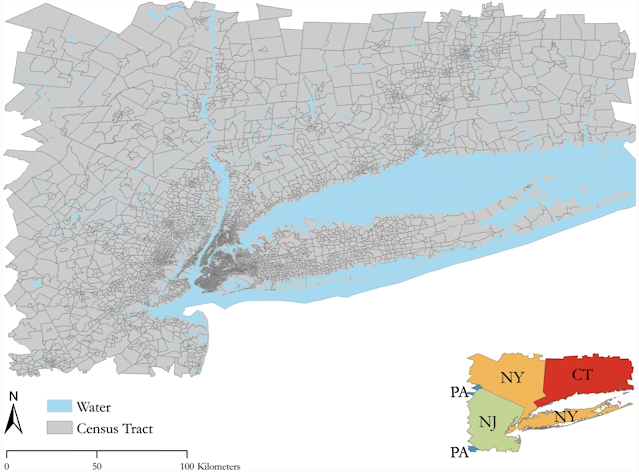
When developing geographically explicit agent-based models, one thing we spend a lot of time on is building synthetic populations and then linking the agents in the synthetic population to each other.  To overcome this issue we have a new paper published in "Computational Urban Science " entitled "A method to create a synthetic population with social networks for geographically-explicit agent-based models" In this paper  Na (Richard) Jiang, Hamdi Kavak, Annetta Burger, William Kennedy and myself present a synthetic population generation method that also includes social networks and use the New York Metro as a study site, which covers an area of 262 x 234 km and is home to over 23 million people. 

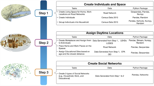
To show the utility of this method we also present three simple applications (e.g., a disease , a disaster  and a traffic model) which utilize different parts of this synthetic population but are all geographically explicit and use networks in some shape or form. If this sounds of interest, below you can read the abstract from the paper, along with seeing some of the figures from our methodology and example applications. While at the bottom of the post we provide the full citation and a link to the paper. The paper itself also has links to actual code that generates the synthetic population and the resulting datasets and models  (code: https://bit.ly/SynPopABM; source and resulting synthetic population data: https://osf.io/3vsaj/) .  

Abstract

Geographically-explicit simulations have become crucial in understanding cities and are playing an important role in urban science. One such approach is that of agent-based modeling which allows us to explore how agents interact with the environment and each other (e.g., social networks), and how through such interactions aggregate patterns emerge (e.g., disease outbreaks, traffic jams). While the use of agent-based modeling has grown, one challenge remains, that of creating realistic, geographically-explicit, synthetic populations which incorporate social networks. To address this challenge, this paper presents a novel method to create a synthetic population which incorporates social networks using the New York Metro Area as a test area. To demonstrate the generalizability of our synthetic population method and data to initialize models, three different types of agent-based models are introduced to explore a variety of urban problems: traffic, disaster response, and the spread of disease. These use cases not only demonstrate how our geographically-explicit synthetic population can be easily utilized for initializing agent populations which can explore a variety of urban problems, but also show how social networks can be integrated into such populations and large-scale simulations.

Keywords: Synthetic Population Generation, Agent-Based Modeling, New York, Traffic Dynamics, Disease, Disaster

Study Area

Workflow for Generation of Synthetic Population and Networks

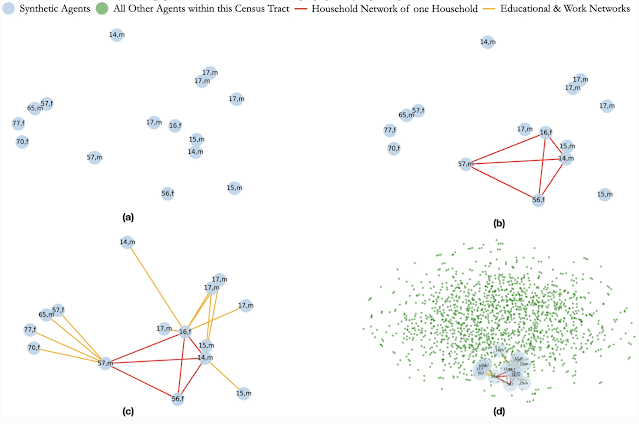
Creation of Social Networks: (a) Selected Population; (b) Creation of a Household Network; (c) Creation of Work and Educational Networks for each Member of the Household; (d) The Household, its Networks within the Full Census Tract

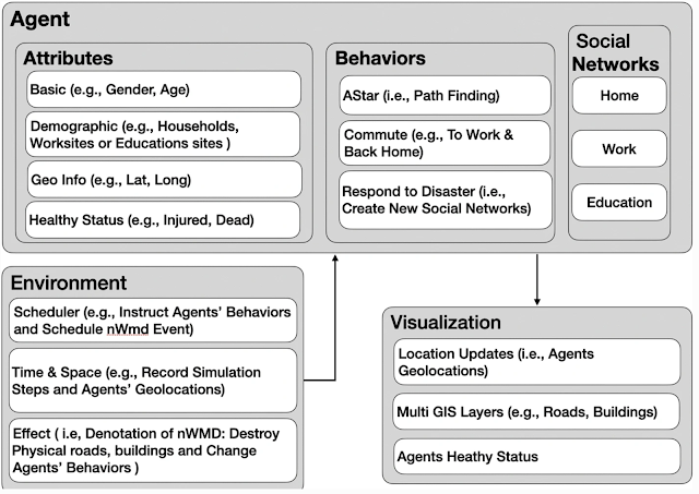
Model Component Structure of Population Respond to Disaster event

Agents’ Health Status After 1 Minute of the Disaster Event

Full Reference:

Jiang, N., Crooks, A.T., Kavak, H., Burger, A. and Kennedy, W.G. (2022), A Method to Create a Synthetic Population with Social Networks for Geographically Explicit Agent-Based Models, Computational Urban Science, 2:7. Available at https://doi.org/10.1007/s43762-022-00034-1

Thursday, December 02, 2021

Urban life: A model of people and places

We have just wrapped up project that created a simple agent-based simulation of urban life as part of DARPA's Ground Truth Program. To this end we have just published a  new paper entitled "Urban life: a model of people and places" published in Computational and Mathematical Organization Theory, with Andreas Züfle, Carola Wenk, Dieter Pfoser, Joon-Seok Kim, Hamdi Kavak, Umar Manzoor, Hyunjee Jin  and myself. In the paper we provide an overview of the model and how it was used to test and validate human domain research. For interested readers, below you can find the abstract  to the paper along with some images that will give you a sense of our simulation model (which for interested readers was created with MASON and its GIS extension (GeoMason). While at the bottom of the post you can find the full reference and a link to the paper. 

 Abstract

We introduce the Urban Life agent-based simulation used by the Ground Truth program to capture the innate needs of a human-like population and explore how such needs shape social constructs such as friendship and wealth. Urban Life is a spatially explicit model to explore how urban form impacts agents’ daily patterns of life. By meeting up at places agents form social networks, which in turn affect the places the agents visit. In our model, location and co-location affect all levels of decision making as agents prefer to visit nearby places. Co-location is necessary (but not sufficient) to connect agents in the social network. The Urban Life model was used in the Ground Truth program as a virtual world testbed to produce data in a setting in which the underlying ground truth was explicitly known. Data was provided to research teams to test and validate Human Domain research methods to an extent previously impossible. This paper summarizes our Urban Life model’s design and simulation along with a description of how it was used to test the ability of Human Domain research teams to predict future states and to prescribe changes to the simulation to achieve desired outcomes in our simulated world.

Our generated maps colored based on different aggregation levels.

A screenshot of the graphical user interface from a representative model run. Top-Left: The spatial network and agents. Bottom left: Simulation parameters that can be specified prior to simulation start. Top-middle: the social network. Bottom-middle: Summary statistics of the simulation during tun-time such as friendship. Right: Profiles of recreational sites.

Screenshot of the epidemic simulator depicting the French Quarter, New Orleans, LA, USA.

Full Reference:

Züfle, A., Wenk, C., Pfoser, D., Crooks, A.T., Kavak, H., Kim, J-S. and Jin, H. (2021), Urban Life: A Model of People and Places, Computational and Mathematical Organization Theory. Available at https://doi.org/10.1007/s10588-021-09348-7 (pdf)

Friday, October 25, 2019

Papers at CSSSA Conferece

At the  2019 Computational Social Science Society of Americas (CSSSA) Conference, we have two papers being presented which relates to our interests in urban simulation. Full citations and links to them are provided at the bottom of this post, while what follows provides a brief overview to them. Turning first to the the paper entitled "Capturing the Effects of Gentrification on Property Values: An Agent-Based Modeling Approach," co-authored with Niloofar Bagheri-Jebelli and Bill Kennedy explores how agents choices for specific locations within a city leads to gentrification occurring. The  model and data that accompanies the paper can be found at: https://github.com/niloofar-jebelli/UrbanDynamics, while below we provide the abstract of the paper, the graphical user interface of the model along with movie of one simulation run with default model settings.

Abstract:
Cities are complex systems which are constantly changing because of the interactions between the people and their environment. Such systems often go through several life cycles which are shaped by various processes. These may include urban growth, sprawl, shrinkage, and gentrification. These processes affect the urban land markets which in turn affect the formation of a city through feedback loops. Through models we can explore such dynamics, populations, and the environments in which people inhabit. The model proposed in this paper intends to simulate the aforementioned dynamics to capture the effect of agents’ choices and actions on the city structure. Specifically, this model explores the effect of gentrification on population density and housing values. The proposed model is significant in its integration of ideas from complex systems theory which is operationalized within an agent-based model stylized on urban theories to study gentrification as a cause of increased in land values. The model is stylized on urban theories and results from the model show that the agents move to and reside in properties within their income range, neighboring agents that have similar economic status. The model also shows the role of gentrification by capturing both the supply and demand aspects of this process in the displacement and immobilization of agents with lower incomes. This is one of the first models that combines several processes to explore the life cycle of a city through agent-based modeling.

Keywords: Urban Dynamics, Land Markets, Gentrification, Urban Growth, Urban Shrinkage, Urban Sprawl.

Model graphical user interface at default settings.


Gentrification by demand in the 10th neighborhood of the inner-city.

Turning to our second paper which was presented as a poster, entitled "Modeling Social Networks in an Agent-Based Model of a Nuclear Weapon of Mass Destruction Event" we discussed our continuing  work on disasters. Specifically our project on how people might react in an event of  Nuclear Weapon of Mass Destruction (NWMD) in New York City when one integrates social networks into an agent-based model. In the paper we discuss preliminary results which demonstrate how we can integrate  household social networks explicitly into a spatially explicit model. Furthermore we demonstrate and benchmark agent commuting patterns for the New York City Commuter Region with a sample population  (as we show in one of the movies below) along with demonstrating agents initial reactions post NWMD detonation.

Abstract:
Connections between human beings often influence where people go and how they behave, yet their representation as social networks are rarely modeled as a factor of human behavior in agent-based models. Social networks are increasingly being used to study human behavior in disasters, and empirical work has shown that human beings prioritize the safety of themselves and loved ones (i.e., households) before helping neighbors and coworkers. In this poster, we briefly present our agent-based model being used to characterize the New York City area population’s reaction to a Nuclear Weapon of Mass Destruction (NWMD) event. The model methodology demonstrates how social networks can be integrated into an agent-based model and act as a basis for decision-making during a disaster. Preliminary simulations show how agents potentially respond to a NWMD event with measurable changes in location and network formations over space and time.
Keywords: Agent-Based Model, Human Behavior, Social Networks, Emergency, Disaster Response, Nuclear Weapon of Mass Destruction.


References
Bagheri-Jebelli, N., Crooks, A.T. and Kennedy, W.G. (2019), Capturing the Effects of Gentrification on Property Values: An Agent-Based Modeling Approach, The 2019 Computational Social Science Society of Americas Conference, Santa Fe, NM. (pdf)

Burger, A. G., Kennedy, W.G., Crooks, A.T., Jiang, N. and Guillen-Piazza, D. (2019), Modeling Social Networks in an Agent-Based Model of a Nuclear Weapon of Mass Destruction Event, The 2019 Computational Social Science Society of Americas Conference, Santa Fe, NM. (paper pdf) (poster pdf)

Monday, July 01, 2019

Modeling Society Reacting to a Nuclear Weapon of Mass Destruction Event

https://www.dropbox.com/s/mid39pfgvu1vr8l/SBPBrims_2019_Poster.pdf?dl=0
Over the last couple of years we have been working on generating synthetic human populations with realistic social networks with respect to the New York mega-city and surrounding region. This is being done for a variety of modeling applications such as the spread of a disease or exploring peoples reactions to disasters (which was a topic of a recent post on Computational Social Science of Disasters).

To this end, at the upcoming International Conference on Social Computing, Behavioral-Cultural Modeling and; Prediction and Behavior Representation in Modeling and Simulation (or SBP-BRiMS for short) we have a short working paper outlining some of our initial efforts to how people might react following a Nuclear Weapon of Mass Destruction (NWMD) event. In the paper we show some preliminary simulation results relating on  how we are able to simulate basic commuting patterns and initial movement away from the affected area after the NWMD event (like those in the movies below). By using a synthetic population we are able to create an artificial world populated by agents with sufficient heterogeneity to create realistic movement patterns and the social networks which play a vital role in disaster situations. If you want to know more about this work, feel free to read the abstract below or read the paper. 

Abstract:
Individual connections between human beings often dictate where people go and how they behave, yet their representation through social networks are rarely used as measures of human behavior in agent-based models. Social networks are increasingly used for study of human behavior in disasters, and empirical work has shown that human beings prioritize the safety of themselves and loved ones (i.e., households) before helping neighbors and coworkers. Based on this assumption we have created a set of heuristics for modeling how agents behave in an emergency event and how the individual behavior aggregates into a variety of patterns of life. In this paper will present briefly our agent-based model being used to characterize the population’s reaction to a Nuclear Weapon of Mass Destruction (NWMD) event in the New York City region. Agents are modeled commuting on work-day schedules before the explosion of a small (10Kt) nuclear device. After the explosion, agents respond to signals in their environment and make decisions based on prioritization of safety for themselves and those in their networks. The model methodology demonstrates how social networks can be integrated into an agent-based model and act as a basis for decision-making, and preliminary simulations show how agents potentially respond to a NWMD event with measurable changes in location and network formations over space and time. 

Keywords: Agent-Based Model, Human Behavior, Social Networks, Emergency, Disaster Response, Nuclear Weapon of Mass Destruction.
Various patterns of commuting behavior representing daily routines of the individual agents.


Full Reference:
Burger, A. G., Kennedy, W.G., Crooks, A.T., Jiang, N. and Guillen-Piazza, D. (2019), Modeling Society Reacting to a Nuclear Weapon of Mass Destruction Event, 2019 International Conference on Social Computing, Behavioral-Cultural Modeling and Prediction and Behavior Representation in Modeling and Simulation, Washington DC. (pdf)

Wednesday, September 19, 2018

An Agent-Based Model of Rural Household Adaptation to Climate Change

Geographical location of the South Omo Zone of Ethiopia
While many of the recent posts on the site have focused on social media, social networks and volunteered geographical information, we have not forgotten or moved away from agent-based modeling (as you can probably gather from the title of this post).  To this end, Ates Hailegiorgis, Claudio Cioff-Revilla and myself recently had a paper published in the Journal of Artificial Societies and Social Simulation entitled: An Agent-Based Model of Rural Household Adaptation to Climate Change

The purpose of the model is to explore how climate change could impact rural societies in less developed countries whose livelihoods rely on subsistence agriculture. It has been suggested that climate change will place unprecedented stress on rural communities, as it will alter their resource base without giving them sufficient time for adaptation. While rural systems have developed various adaptive strategies over many generations in order to survive, the alteration of any resources can significantly affect even highly regarded and accepted customs, and may lead to the displacement of populations along with other severe humanitarian consequences.

In this paper we focus on the South Omo Zone of Ethiopia which covers an area of 2.3 million hectares and is located in the southern part of Ethiopia. Climate change is expected to play a significant role in shaping the future socio-ecological setting of the region and to explore this we devlepd a model  in the MASON simulation system, including its geographical information system (GIS) extension, GeoMASON called OMOLAND-CA (OMOLAND Climate Change Adaptation). Results from the model show that successive episodes of extreme events (e.g., droughts) can affect the adaptive capacity of households in the region, causing them to migrate from the region. While at the same time the rural communities manage to endure in spite of such harsh climatic change conditions.

Below you can read the abstract of the paper, see some of the figures including the models high-level architecture, along with the household decision-making process, some results from various scenarios and a link to the model and the full reference of the paper.

Abstract: 
Future climate change is expected to have greater impacts on societies whose livelihoods rely on subsistence agricultural systems. Adaptation is essential for mitigating adverse effects of climate change, to sustain rural livelihoods, and ensure future food security. We present an agent-based model, called OMOLAND-CA, which explores the impact of climate change on the adaptive capacity of rural communities in the South Omo Zone of Ethiopia. The purpose of the model is to answer research questions on the resilience and adaptive capacity of rural households with respect to variations in climate, socioeconomic factors, and land-use at the local level. Our model explicitly represents the socio-cognitive behavior of rural households toward climate change and resource flows that prompt agents to diversify their production strategy under different climatic conditions. Results from the model show that successive episodes of extreme events (e.g., droughts) affect the adaptive capacity of households, causing them to migrate from the region. Nonetheless, rural communities in the South Omo Zone, and in the model, manage to endure in spite of such harsh climatic change conditions.

Keywords: Climate Change Adaptation, Agent-Based Modeling, Socio-Cognitive Behavior

High-level architecture of the OMOLAND-CA model.

Household decision-making sequence for each time period in the model.

Population migration over time with different climatic conditions: a) 50% reduction, b) 70% reduction, c) 90% reduction of rainfall with different drought frequencies.

Livestock growth over time with different climatic conditions: a) 50% reduction, b) 70% reduction, c) 90% reduction of rainfall with different drought frequencies.
Simulation results of the frequency of crop planted per hectare.


In keeping with many of our agent-based models that we have created, a full description of the model (using the Overview, Design concepts, and Details plus Decision (ODD+D) protocol), along with its source code and data needed to run the model can be found at: https://www.openabm.org/model/5734/ .

Full Reference:
Hailegiorgis, A.B., Crooks, A.T. and Cioff-Revilla, C. (2018), An Agent-Based Model of Rural Households’ Adaptation to Climate Change, Journal of Artificial Societies and Social Simulation, 21 (4): 4. Available at http://jasss.soc.surrey.ac.uk/21/4/4.html.
 

Wednesday, July 04, 2018

MASON Update

At the upcoming Multi-Agent-Based Simulation (MABS) workshop, we have a paper entitled "The MASON Simulation Toolkit: Past, Present, and Future" in which we discuss MASON's development history, its design and (probably more interesting) where MASON is going. This includes:
  1. Making it more robust (i.e. easier to run parameter tests), 
  2. Making it distributed in order to  run large scale models including geographical explicit ones along for optimization and validation purposes.
  3. Making it more coder-friendly by adding code templates that allow users to generate code skeletons for common MASON patterns and a way to easily record outputs and statistics.
  4. Making it more community-friendly by hopefully developing a special online repository to enable researchers to distribute models as jar files along with education aids and examples. Relating to this last point we have added a number of example models (code and data) from our own research to GitHub, see: https://github.com/eclab/mason/tree/master/contrib/geomason/sim/app/geo and the data to run the models is either there or here https://cs.gmu.edu/~eclab/projects/mason/extensions/geomason/geodemodata.zip (note this is 1.5 GB).
Below you can read the abstract from the paper along with a link to the paper itself.

Example Applications of MASON

Abstract
MASON is a widely-used open-source agent-based simulation toolkit that has been in constant development since 2002. MASON’s architecture was cutting-edge for its time, but advances in computer technology now offer new opportunities for the ABM community to scale models and apply new modeling techniques. We are extending MASON to provide these opportunities in response to community feedback. In this paper we discuss MASON, its history and design, and how we plan to improve and extend it over the next several years. Based on user feedback will add distributed simulation, distributed GIS, optimization and sensitivity analysis tools, external language and development environment support, statistics facilities, collaborative archives, and educational tools.

Keywords: Agent-Based Simulation, Open Source, Library

Full Reference:
Luke, S., Simon, R., Crooks, A.T., Wang, H., Wei, E., Freelan, D., Spagnuolo, C., Scarano, V., Cordasco, G. and Cioffi-Revilla, C. (2018), The MASON Simulation Toolkit: Past, Present, and Future, 19th International Workshop on Multi-Agent-Based Simulation (MABS2018), Stockholm, Sweden. (pdf)

Available on Github


This research is supported by the National Science Foundation (Grant 1727303).

Tuesday, May 29, 2018

Spatial Agent-based Models of Human-Environment Interactions: Spring 2018

During the past spring semester I taught a class entitled "Spatial Agent-based Models of Human-Environment Interactions". As with many of my courses, students are expected to complete a end of semester project, in this case, develop an agent-based model that explores some aspect of related to the course theme of human-environment interactions. In the movie below is a selection of these projects can be seen. The projects ranged from urban growth, housing markets, the adoption of solar energy, employment opportunities, populations at risk from terrorism, commuting, to the spread of diseases. Many of the models were done in NetLogo, MASON and some in Python including using MESA.


I would like to thank the Students of CSS 645: Spatial Agent-based Models of Human-Environment Interactions for their participation in the class.

Tuesday, October 18, 2016

Modeling the Emergence of Riots: A Geosimulation Approach


As you might of guessed the paper is about riots but that is not all. In the paper we have a highly detailed cognitive model implemented through the PECS (Physical conditions, Emotional state, Cognitive capabilities, and Social status) framework based around identity theory. The purpose of the model (and paper) is to explore how the unique socioeconomic variables underlying Kibera, a slum in Nairobi, coupled with local interactions of its residents, and the spread of a rumor, may trigger a riot such as those seen in 2007. 

In order to explore this question from the "bottom up" we have developed a novel agent-based model that integrates social network analysis (SNA) and geographic information systems (GIS) for this purpose. In the paper we argue that this integration facilitates the modeling of dynamic social networks created through the agents’ daily interactions. The GIS is used to develop a realistic environment for agents to move and interact that includes a road network and points of interest which impact their daily lives.

Below is the abstract and a summary of its highlights in order to give you a sense of what our research contribution is. In addition to this we also provide some images either from the paper itself or the from Overview, Design Concepts, and Details (ODD) protocol. Finally at the bottom of this post you can see one of the simulation runs, details of where the model can be downloaded along with the full citation.

Paper Abstract:
Immediately after the 2007 Kenyan election results were announced, the country erupted in protest. Riots were particularly severe in Kibera, an informal settlement located within the nations capital, Nairobi. Through the lens of geosimulation, an agent-based model is integrated with social network analysis and geographic information systems to explore how the environment and local interactions underlying Kibera, combined with an external trigger, such as a rumor, led to the emergence of riots. We ground our model on empirical data of Kibera’s geospatial landscape, heterogeneous population, and daily activities of its residents. In order to effectively construct a model of riots, however, we must have an understanding of human behavior, especially that related to an individual’s need for identity and the role rumors play on a person’s decision to riot. This provided the foundation to develop the agents’ cognitive model, which created a feedback system between the agents’ activities in physical space and interactions in social space. Results showed that youth are more susceptible to rioting. Systematically increasing education and employment opportunities, however, did not have simple linear effects on rioting, or even on quality of life with respect to income and activities. The situation is more complex. By linking agent-based modeling, social network analysis, and geographic information systems we were able to develop a cognitive framework for the agents, better represent human behavior by modeling the interactions that occur over both physical and social space, and capture the nonlinear, reinforcing nature of the emergence and dissolution of riots.

Keywords: agent-based modeling; geographic information systems; social network analysis; riots; social influence; rumor propagation.

Paper Highlights:
  • An agent-based model integrates geographic information systems and social network analysis to model the emergence of riots. 
  • The physical environment and agent attributes are developed using empirical data, including GIS and socioeconomic data. 
  • The agent’s cognitive framework allowed for modeling their activities in physical space and interactions in social space. 
  • Through the integration of the three techniques, we were able to capture the complex, nonlinear nature of riots. 
  • Results show that youth are most vulnerable, and, increasing education and employment has nonlinear affects on rioting.

The high-level UML diagram of the model


A high-level representation of the model’s agent behavior incorporated into the PECS framework

An example of the evolution of social networks of ten Residents across the first two days of a simulation run.

The movie below shows the agent-based model which explores ethnic clashes in the Kenyan slum. The environment is made up of households, businesses, and service facilities (such data comes from OpenStreetMap). Agents within the model use a transportation network to move across the environment. As agents go about their daily activities, they interact with other agents - building out an evolving social network. Agents seek to meet their identity standard. Failure to reach their identity standard increases the agents frustration which can lead to an aggressive response (i.e. moving from blue to red color) such as rioting.


As with many of our models, we provide the data, model code and detailed model description in the form of the ODD protocol for others to use, learn more or to extend. Click here for more information.

Full Reference:
Pires, B. and Crooks, A.T. (2017), Modeling the Emergence of Riots: A Geosimulation Approach, Computers, Environment and Urban Systems, 61: 66-80. (pdf)
As normal, any thoughts or comments are most appreciated.
 

Monday, August 15, 2016

Summer Projects

Over the summer, Arie Croitoru and myself took part in the George Mason University Aspiring Scientists Summer Internship Program. We worked with three very talented high-school students who over the course of the seven and a half week program produced some excellent research around the areas of agent-based modeling and social media analysis. An overview of their work can be seen in the posters and abstracts that the students produced at the end of the internship.

Lawrence Wang explored how social media could be used with respect to predicting election results under a project entitled "And the Winner Is? Predicting Election Results using Social Media". Below you can read Lawrence's abstract and see his poster.

"The 2012 U.S. presidential election demonstrated how Twitter can serve as a widely accessible forum of political discourse. Recently, researchers have investigated whether social media, particularly Twitter, can function as a predictive tool. In the past decade, multiple studies have claimed to successfully predict the results of elections using Twitter data. However, many of these studies fail to account for the inherent population bias present in Twitter data, leading to ungeneralizable results. In this project, I investigate the prospects of using Twitter data as an alternative to poll data for predicting the 2012 presidential election. The tweet corpus consisted of tweets published one month before the November election day. Using VADER, a sentiment analysis tool, I analyzed over 140,000 tweets for political sentiment. I attempted to circumvent the Twitter population bias by comparing age, race, and gender metrics of the Twitter population with that of the U.S. population. Furthermore, I utilized Bayesian inference with prior distributions from the results of the 2008 presidential election in order to mitigate the effects of limited tweet data in certain states. The resulting model correctly predicted the likely outcomes of 46 of the 50 states and predicted that President Obama would be reelected with a probability of 0.945. Such a model could be used to explore the forthcoming elections. " 


In a second project, Varun Talwar, explored how knowledge bases could be utilized to better contextualize social media discussions with a project entitled "Context Graphs: A Knowledge-Driven Model for Contextualizing Twitter Discourse." Below you can read Varun's project abstract and his end of project poster.

"Introduction: User posted content through online social media (SM) platforms in recent years has emerged as a rich field for narrative analysis of topics captured during the discussion discourse. In particular, collective discourse has been used to manually contextualize public perception of health related events.

Objective: As SM feeds tend to be noisy, automated detection of the context of a given SM discourse stream has proven to be a challenging task. The primary objective of this research is to explore how existing knowledge bases could be utilized to better contextualize SM discussions through topic modeling and mining. By utilizing such existing knowledge it would then be possible to explore to what extent a given discourse is related to a known or a new context, as well as compare and contrast SM discussions through their respective contexts.

Methods: In order to accomplish these goals this research proposes a novel approach for contextualizing SM discourse. In this approach, topic modeling is combined with a knowledgebase in a two-step process. First, key topics are extracted from a SM data corpus by applying a statistical topic-modeling algorithm, a process that also results in data dimensionality reduction. Once a set of salient topics are extracted, each topic is then used to mine the knowledge base for sub graphs that represent the contextual linkages between knowledge elements. Such sub-graphs can then further disambiguate the topic modeling results, and be utilized for qualifying context similarity across SM discussions.

Results: The time-series analysis of the Twitter discourse via graph-matching algorithms reveals the change in topics as evidenced by the emergence of the terms “pregnancy” and “abortion” as information about the virus propagated through the Twitter community. "


Elizabeth Hu explored the current migration crisis in Europe in a project entitled "Across the Sea: A Novel Agent-Based Model for the Migratory Patterns of the European Refugee Crisis". Below is Elizabeth's abstract, poster and an example model run.

"Since 2010, a growing number of refugees have sought asylum in European nations, fleeing violence and military conflict in their home countries. Most of the refugees originate from Syria, Iraq, Afghanistan, and African nations. The vast majority of refugees risk their lives in the popular yet perilous Mediterranean Sea Route often prone to boat accidents and subsequent deaths of migrants.  The flow of millions of refugees has introduced a humanitarian crisis not seen since World War II. European nations are struggling to cope with the influx of refugees through various border policies.

In order to explore this crisis, a geographically explicit agent-based model has been developed to study the past and future patterns of refugee flows. Traditional migration models, which represent the population as an aggregate, fail to consider individual decision-making processes based on personal status and intervening opportunities. However, the novel agent-based model developed here of migration allows population behavior to emerge as the result of individual decisions. Initial population, city, and route attributes are based upon data from the UNHCR, EU agencies, crowd-sourced databases, and news articles. The agents, refugees, select goal destinations in accordance with the Law of Intervening Opportunities. Thus, goals are prone to change with fluctuating personal needs. Agents choose routes not only based on distance, but also other relevant route attributes. The resulting migration flows generated by the model under various circumstances could provide crucial guidance for policy and humanitarian aid decisions."


The movie below gives a sense of the migration paths the refugees are taking.


Wednesday, June 22, 2016

The Geography of Conflict Diamonds: The Case of Sierra Leone

At the forthcoming  2016 International Conference on Social Computing, Behavioral-Cultural Modeling, and  Prediction and Behavior Representation in Modeling and Simulation. we will be presenting a paper is entitled "The Geography of Conflict Diamonds: The Case of Sierra Leone" The abstract and some of the figures from the paper are below. At the bottom of the post you can find the full reference and a link to the paper and model.
In the early 1990s, Sierra Leone entered into nearly 10 years of civil war. The ease of accessibility to the country's diamonds is said to have provided the funding needed to sustain the insurgency over the years. According to Le Billon, the spatial dispersion of a resource is a major defining feature of a war. Using geographic information systems to create a realistic landscape and theory to ground agent behavior, an agent-based model is developed to explore Le Billon's claim. Different scenarios are explored as the diamond mines are made secure and the mining areas are moved from rural areas to the capital. It is found that unexpected consequences can come from minimally increasing security when the mining sites are in rural regions, potentially displacing conflict rather than removing it. On the other hand, minimal security may be sufficient to prevent conflict when resources are found in the city.

Motives and action-guiding motive via the Intensity Analyzer

A visual comparison of model results to actual events. a: Average model results using default parameter values. b: Actual event intensity.


Full Reference:
Pires, B. and Crooks, A.T. (2016), The Geography of Conflict Diamonds: The Case of Sierra Leone, in Xu, K. S., Reitter, D., Lee, D. and Osgood, N. (eds.), Proceedings of the 2016 International Conference on Social Computing, Behavioral-Cultural Modeling, and Prediction and Behavior Representation in Modeling and Simulation, Washington, DC, pp. 335-345. (pdf)
A full description of the model and source code along with the data is available at: https://www.openabm.org/model/4955/

Saturday, August 29, 2015

Summer Research Projects

Over the summer, Arie Croitoru and myself took part for the first time in the George Mason University Aspiring Scientists Summer Internship Program (ASSIP). We worked with three very talented high-school students who over the course of the seven and a half week program produced some excellent research around the areas of agent-based modeling (ABM), volunteered geographical analysis (VGI), social media and text analysis. An overview of their work can be seen below in the posters and abstracts that the students produced at the end of the internship.

End of Summer Research Poster Display
In the first project, Kevin Geng and Varun Talwar explored how online news stories propagate around the world in a project entitled: "MediaPulse: A System Prototype for News Media Aggregation and Analytics". We would also like to thank Trevor Thrall for his assistance and guidance in this project. Below you can read the abstract and see the poster from this work.
"The news media play a major role in shaping the opinions and beliefs of people around the globe. Alongside more traditional media distribution modes, such as the printed press, in recent years the Internet has begun to play a more important role in news distribution. With the emergence of online news, information can now be disseminated across the globe in real-time. By monitoring such online sources, we can, for the first time, obtain valuable insight into the propagation of news around the world over time, and understand how such media is both produced and consumed. However, obtaining and analyzing this data on a massive scale has proven to be challenging. To address this challenge, we present a novel system for the collection and analysis of news articles. Our system has the capability to extract both metadata and text from a large array of online news sources, and analyze it with respect to themes, locations, time, and language. In order to showcase the utility of our system, we selected 440 prominent news sources across the globe, and monitored their RSS feeds every hour using our system. Through this process we collected roughly 30,000 articles per day over the duration of the study period. To demonstrate the analytical capabilities of our system, we present a case study analysis of coverage of the Islamic State of Iraq and Syria (ISIS) using the system that we developed. In particular, we analyze ISIS-related news using both their content and metadata to show how news propagates over time and space, and explore how the sentiment of the coverage varies."


In a second project Rohan Suri developed an agent-based model to explore the spread and  containment of Ebola in a project entitled "A novel computational agent based model for the spread and containment of Ebola Virus Disease". Below is the abstract, poster and a example model run from this project. More information about the model can be found here.
"During the Summer of 2014, the countries of Sierra Leone, Guinea, and Liberia were devastated by an Ebola Virus Disease (EVD) epidemic.  Although it killed more than 10,000 people, little is known about EVD dynamics in a macro population. While various attempts have been made to better understand EVD dynamics, such past attempts at modeling EVD exclude an explicit spatial scale, implied general mixing, and did not consider human-to-human interactions. In view of these limitations, this research aims to develop a novel computational agent based model (ABM) to investigate spatial and temporal EVD spread, and to study the effectiveness of control and prevention measures for EVD. In this model, OpenStreetMap (OSM) data was used to construct the physical environment (e.g., road networks), and a realistic population for the three countries was generated from Landscan data and previous surveys. EVD spread was modeled through explicit agent-to-agent interaction and the use of a Suspected-Infected-Exposed-Recovered (SEIR) model"


It was a great learning experience from our side by participating in the ASSIP Program.


Saturday, January 31, 2015

New Book Chapter: Agent-based modelling and geographical information systems

Chris Brunsdon and Alex Singleton recently edited a book entitled "Geocomputation: A Practical Primer". The book covers a plethora of topics relating to geocomputation, and to quote from the website: "Chapters provide highly applied and practical discussions of:
      • Visualization and exploratory spatial data analysis
      • Space time modelling
      • Spatial algorithms
      • Spatial regression and statistics
      • Enabling interactions through the use of neogeography "
In the book I contributed a chapter on "Agent-based Models and Geographical Information Systems". Such a topic might not come as a surprise to readers of this blog but I essentially wanted to showcase a series of applications that we have been working on here at George Mason University and moreover, provide a general introduction to agent-based modeling (ABM) and how to link it to geographical information.

The main argument of the chapter is that the ABM paradigm provides a mechanism for understanding the effects of interactions of individuals and through such interactions emergent structures develop, both in the social and physical environment. By coupling agent-based models to geographical information systems (GIS), spatially explicit agent-based models can be created exploring the complexities of our world from the bottom-up. 

Representing the world as a series of layers of fixed and
non-fixed objects (adapted from Benenson and Torrens, 2004).

The chapter therefore introduces agent-based models to those interested in geocomputational methods, argues why such models should be used to study geographical problems before discussing how one can use GIS to create geographical explicit agent-based models. Through a series of examples we demonstrate how raster or vector spatial data can be used to model various aspects of our daily lives from that of the micro movement of pedestrians over seconds and minutes, to that of the macro patterns of urban growth over years and decades. By integrating spatial data and agent-based models at different spatial and temporal scales, such a modeling approach provides the flexibility to aid social scientists to explore the complex world that we inhabit.

Many of the models discussed in the chapter were either created in NetLogo or MASON. If you look at my research page you can find the source code to most of these models.  

A sample of application domains for spatial agent-based models discussed in the chapter.

A simple example using MASON on how Agent-based models can be to used explore rush hour congestion:
(A): Road and census data used for model inputs. (B) Zoomed in section of A with agents (red circles)
moving towards Tyson’s Corner and causing traffic jams.

Reference Cited:
Benenson, I. and Torrens, P.M. (2004), Geosimulation: Automata-Based Modelling of Urban Phenomena, John Wiley & Sons, London, UK.
Full Reference to Chapter:
Crooks, A.T. (2015), Agent-based Models and Geographical Information Systems, in Brunsdon, C. and Singleton, A. (eds.), Geocomputation: A Practical Primer, Sage, London, UK, pp. 63-77. (pdf)
Happy reading, and if you cannot find the models discussed in the chapter, feel free to drop me an email and I can point you in the right direction.