Wednesday, December 21, 2016

A semester with CSS

This last semester I gave both a graduate and undergraduate course in Computational Social Science (CSS). Both courses survey computational approaches such as system dynamics, social network analysis, machine learning, cellular automata, discrete event simulation, agent-based modeling, and microsimulation to study social phenomena with emphasis on complexity theory.

For the undergraduate class, we met twice a week. In the first class of each week I would outline the topic,  discuss a specific modeling approach and give a range of sample applications. While the second class of the week was devoted to hands on model development (I chose to use NetLogo for this), in order to cement what was discussed in the first class (a learning by doing if you like.). For example, one week we discussed cellular automata (CA) modeling, where in the first class, I outlined its evolution, its basic proprieties and applications (e.g. from simple voting models to that of urban growth). In the second class, the students then built a CA model from scratch.  For the graduate class, more emphasis was placed on theory, critiques of modeling and discussion of key texts.

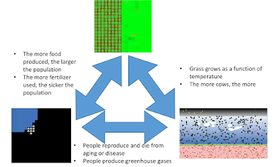
In both classes, all the students needed to carry out a project where they develop a computational model that investigates a social science research question. This exercise is often their first model (especially for the undergraduates) that many students ever create. Below you can see some of this years models.


Thursday, December 01, 2016

International Congress on Agent Computing


Between the 29th and 30th of November, the International Congress on Agent Computing was held at George Mason University. It was organized to celebrate the 20th anniversary of the publication of Growing Artificial Societies by Robert Axtell and Joshua Epstein. The congress brought together a great line up of interdisciplinary keynote speakers: Brian Arthur, Mike Batty, Stuart Kauffman and  David Krakauer and a  panel discussion entitled "Barriers to Progress in Agent Computing—Technical and Social" with Chris Barrett, Steven Kimbrough, Blake LeBaron, Dawn ParkerFlaminio Squazzoni and Leigh Tesfatsion. Along with the keynotes and there panel there were also over 19 posters and 59 presentations which showcased and demonstrated the theme of the congress, that of the:
"explosive growth of agent modeling over the past two decades in the social sciences, in business and government, and related areas, and offer a tour d’horizon of its present state and myriad applications. Looking forward, we will identify challenges and opportunities — Hilbert Problems, if you will — to shape the future of agent-based computational modeling."

Joshua Epstein and Robert Axtell presenting their works.

Josh and Rob each gave really impressive talks entitled “Agent-­based modeling: From Napkins to Nations” and "The Adoption of Agent Computing over Time by Social Scientists as Compared to Game Theory and Experimental/ Behavioral Economics" respectively. Which reflected how agent computing has evolved over the last 20 years with plenty of funny anecdotes along the way including references and critiques of their works such as "masculine gods of their cyberspace creations" and where the field is going.

What really impressed me about the congress was the atmosphere. That of like minded individuals from many different disciplines coming together and discussing agent computing, complexity and modeling more generally.  Some of this can be seen via photos and tweets of the event.

Alison Heppenstall, Nick Malleson and myslef also participated at the congress with a talk entitled "ABM for Simulating Spatial Systems: How are we doing?" which assessed how has agent-based modeling within the geographical sciences advanced over the last 20 years. Below one can read a brief outline of the talk and a movie of presentation.

Abstract:
While great advances in modeling have been made, one of the greatest challenges we face is that of understanding human behavior and how people perceive and behave in physical spaces. Can new sources of data (i.e. “big data”) be used to explore the connections between people and places?   In this paper we will review of the current state of art of modeling geographical systems.  We highlight the challenges and opportunities through a series of examples that new data can be used to better understand and simulate how individuals behave within geographical systems.

Key Words: Agent-based Modeling, Geographical Information Science, Networks, Cities, Geographical Systems.


Reference:
Heppenstall, A., Crooks A.T. and Malleson, N. (2016), ABM for Simulating Spatial Systems: How are we doing? International Congress on Agent Computing, 29th-30th, November, Fairfax, VA.

The Growth of Geographical  ABM (selected examples).

Monday, November 28, 2016

New Paper: Close, But Not Close Enough


At the 2016 The Computational Social Science Society of Americas Conference Tom Briggs and myself had a paper accepted entitled "Close, But Not Close Enough: A Spatial Agent-Based Model of Manager-Subordinate Proximity". In the paper we present our  preliminary effort to explore how workplace layout impacts on subordinates interactions with managers. We developed a spatial agent-based model to simulate how the physical seating locations of individuals with reporting relationships might enhance or detract from an effective manager-subordinate relationship. Below you can read the abstract of our paper and find out more information about the model.


Abstract:
Employees may be co-located with their manager or they may be separated by distances ranging from a short walk to across oceans, with many gradations in between. Some distances, such as those between floors of an office building, are physically short but may be psychologically quite far. The current project developed a spatial ABM to examine the likelihood of unplanned manager-subordinate encounters in an office setting with two floors. Early results suggest that subordinates located on a different floor than their manager are substantially less likely to have even a single spontaneous encounter with their manager in a work day, despite a relatively short physical separation. If leader-follower (i.e., manager-subordinate) relationships are influenced by spontaneous face-to-face encounters, this finding represents a challenge for organizations with managers having subordinates who are close, but not close enough. Additionally, attempting to impose top-down requirements to travel between floors (e.g., when scheduling meetings) may do surprisingly little to abate this problem. Implications of these findings for organizations are discussed, as are limitations and future research, including possibilities for future model verification and validation.

Keywords: workplace design, supervision, leadership, management, employee performance, virtual teams, leader distance, collaboration, agent-based modeling, ABM


Full Reference:
Briggs, T. and Crooks, A.T. (2016), Close, But Not Close Enough: A Spatial Agent-Based Model of Manager-Subordinate Proximity. The Computational Social Science Society of Americas Conference, Santa Fe, NM.  (PDF)
Click here to download the model.

Tuesday, October 18, 2016

Modeling the Emergence of Riots: A Geosimulation Approach


As you might of guessed the paper is about riots but that is not all. In the paper we have a highly detailed cognitive model implemented through the PECS (Physical conditions, Emotional state, Cognitive capabilities, and Social status) framework based around identity theory. The purpose of the model (and paper) is to explore how the unique socioeconomic variables underlying Kibera, a slum in Nairobi, coupled with local interactions of its residents, and the spread of a rumor, may trigger a riot such as those seen in 2007. 

In order to explore this question from the "bottom up" we have developed a novel agent-based model that integrates social network analysis (SNA) and geographic information systems (GIS) for this purpose. In the paper we argue that this integration facilitates the modeling of dynamic social networks created through the agents’ daily interactions. The GIS is used to develop a realistic environment for agents to move and interact that includes a road network and points of interest which impact their daily lives.

Below is the abstract and a summary of its highlights in order to give you a sense of what our research contribution is. In addition to this we also provide some images either from the paper itself or the from Overview, Design Concepts, and Details (ODD) protocol. Finally at the bottom of this post you can see one of the simulation runs, details of where the model can be downloaded along with the full citation.

Paper Abstract:
Immediately after the 2007 Kenyan election results were announced, the country erupted in protest. Riots were particularly severe in Kibera, an informal settlement located within the nations capital, Nairobi. Through the lens of geosimulation, an agent-based model is integrated with social network analysis and geographic information systems to explore how the environment and local interactions underlying Kibera, combined with an external trigger, such as a rumor, led to the emergence of riots. We ground our model on empirical data of Kibera’s geospatial landscape, heterogeneous population, and daily activities of its residents. In order to effectively construct a model of riots, however, we must have an understanding of human behavior, especially that related to an individual’s need for identity and the role rumors play on a person’s decision to riot. This provided the foundation to develop the agents’ cognitive model, which created a feedback system between the agents’ activities in physical space and interactions in social space. Results showed that youth are more susceptible to rioting. Systematically increasing education and employment opportunities, however, did not have simple linear effects on rioting, or even on quality of life with respect to income and activities. The situation is more complex. By linking agent-based modeling, social network analysis, and geographic information systems we were able to develop a cognitive framework for the agents, better represent human behavior by modeling the interactions that occur over both physical and social space, and capture the nonlinear, reinforcing nature of the emergence and dissolution of riots.

Keywords: agent-based modeling; geographic information systems; social network analysis; riots; social influence; rumor propagation.

Paper Highlights:
  • An agent-based model integrates geographic information systems and social network analysis to model the emergence of riots. 
  • The physical environment and agent attributes are developed using empirical data, including GIS and socioeconomic data. 
  • The agent’s cognitive framework allowed for modeling their activities in physical space and interactions in social space. 
  • Through the integration of the three techniques, we were able to capture the complex, nonlinear nature of riots. 
  • Results show that youth are most vulnerable, and, increasing education and employment has nonlinear affects on rioting.

The high-level UML diagram of the model


A high-level representation of the model’s agent behavior incorporated into the PECS framework

An example of the evolution of social networks of ten Residents across the first two days of a simulation run.

The movie below shows the agent-based model which explores ethnic clashes in the Kenyan slum. The environment is made up of households, businesses, and service facilities (such data comes from OpenStreetMap). Agents within the model use a transportation network to move across the environment. As agents go about their daily activities, they interact with other agents - building out an evolving social network. Agents seek to meet their identity standard. Failure to reach their identity standard increases the agents frustration which can lead to an aggressive response (i.e. moving from blue to red color) such as rioting.


As with many of our models, we provide the data, model code and detailed model description in the form of the ODD protocol for others to use, learn more or to extend. Click here for more information.

Full Reference:
Pires, B. and Crooks, A.T. (2017), Modeling the Emergence of Riots: A Geosimulation Approach, Computers, Environment and Urban Systems, 61: 66-80. (pdf)
As normal, any thoughts or comments are most appreciated.
 

Tuesday, October 04, 2016

Agent-based Modeling in Geographical Systems

Recently Alison Heppenstall and myslef wrote a short introductory chapter entitled "Agent-based Modeling in Geographical Systems" for AccessScience (a online version of McGraw-Hill Encyclopedia of Science and Technology).

In the chapter we trace the rise in agent-based modeling within geographical systems with a specific emphasis of cities. We briefly outline how thinking and modeling cities has changed and how agent-based models align with this thinking along with giving a selection of example applications. We discuss the current limitations of agent-based models and ways of overcoming them and how such models can and have been used to support real world decision-making.

Conceptualization of an agent-based model where people are connected to each other and take actions when a specific condition is met

 Full Reference:
Heppenstall, A. and Crooks, A.T. (2016). Agent-based Modeling in Geographical Systems, AccessScience, McGraw-Hill Education, Columbus, OH. DOI: http://dx.doi.org/10.1036/1097-8542.YB160741. (pdf)
 

Saturday, October 01, 2016

New Paper: User-Generated Big Data and Urban Morphology

Continuing our work with crowdsourcing and geosocial analysis we recently had a paper published in a special issue of the  Built Environment journal entitled "User-Generated Big Data and Urban Morphology."

The theme of the special issue is: "Big Data and the City" which was guest edited by Mike Batty and includes 12 papers.  To quote from the website

"This cutting edge special issue responds to the latest digital revolution, setting out the state of the art of the new technologies around so-called Big Data, critically examining the hyperbole surrounding smartness and other claims, and relating it to age-old urban challenges. Big data is everywhere, largely generated by automated systems operating in real time that potentially tell us how cities are performing and changing. A product of the smart city, it is providing us with novel data sets that suggest ways in which we might plan better, and design more sustainable environments. The articles in this issue tell us how scientists and planners are using big data to better understand everything from new forms of mobility in transport systems to new uses of social media. Together, they reveal how visualization is fast becoming an integral part of developing a thorough understanding of our cities."
Table of Contents

In our paper we discuss and show how crowdsourced data is leading to the emergence of alternate views of urban morphology that better capture the intricate nature of urban environments and their dynamics. Specifically how such data can provide us information pertaining to linked spaces and geosocial neighborhoods. We argue that a geosocial neighborhood is not defined by its administrative boundaries, planning zones, or physical barriers, but rather by its emergence as an organic self-organized social construct that is embedded in geographical spaces that are linked by human activity. Below is the abstract of the paper and some of the figures we have in it which showcase our work.
"Traditionally urban morphology has been the study of cities as human habitats through the analysis of their tangible, physical artefacts. Such artefacts are outcomes of complex social and economic forces, and their study is primarily driven by traditional modes of data collection (e.g. based on censuses, physical surveys, and mapping). The emergence of Web 2.0 and through its applications, platforms and mechanisms that foster user-generated contributions to be made, disseminated, and debated in cyberspace, is providing a new lens in the study of urban morphology. In this paper, we showcase ways in which user-generated ‘big data’ can be harvested and analyzed to generate snapshots and impressionistic views of the urban landscape in physical terms. We discuss and support through representative examples the potential of such analysis in revealing how urban spaces are perceived by the general public, establishing links between tangible artefacts and cyber-social elements. These links may be in the form of references to, observations about, or events that enrich and move beyond the traditional physical characteristics of various locations. This leads to the emergence of alternate views of urban morphology that better capture the intricate nature of urban environments and their dynamics."

Keywords: Urban Morphology, Social Media, GeoSocial, Cities, Big Data.
City Infoscapes – Fusing Data from Physical (L1, L2), Social, Perceptual (L3) Spaces to Derive Place Abstractions (L4) for Different Locations (N1, N2).


Recreational Hotspots Composed of “Locals” and “Tourists” with Perceived Artifacts Indicating “Use” and “Need”. (A) High Line Park (B) Madison Square Garden.


Moving from Spatial Neighborhoods to Geosocial Neighborhoods via Links.

The Emergence of Geosocial Neighborhoods after the in the
Aftermath of the 2013 Boston Marathon Bombing


Full  Reference: 
Crooks, A.T., Croitoru, A., Jenkins, A., Mahabir, R., Agouris, P. and Stefanidis A. (2016). “User-Generated Big Data and Urban Morphology,”  Built Environment, 42 (3): 396-414. (pdf)

Friday, September 30, 2016

Multi-level Models In NetLogo

http://ccl.northwestern.edu/rp/levelspace/
In the release of NetLogo 6.0, there is an exciting new feature, the ability to have multi-level models. What makes this possible is the introduction of LevelSpace. To quote from the website:
NetLogo gives the example which I show above, whereby one can link three models to find the right balance between a population in terms of "food production with pollution and the environment while growing their society." What I find exciting about this, relates to what we have written about before (e.g. here and here). Basically we often build models which explore only one aspect of urban systems (i.e. a subsystem) at the expense of ignoring others, but there are many aspects of a urban system which are interconnected as I show below.

A Selection of Related Subsystems/processes for Urban Systems
(Source:  Heppenstall et al., 2016)

However, such subsystems do not operate in isolation. In the short term they might appear to be independent from the rest of the system, but in the long run they are dependent on the aggregate system behavior (along with other subsystems). The idea and ease therefore of linking different models together could help explore the urban systems.

Wednesday, September 28, 2016

Understanding the past with Agent-based Models

http://www.pnas.org/content/99/suppl_3/7275.full
I have had a long fascination with the use of agent-based modeling (ABM) to explore past cultures and civilizations. There are a number of very good models which I will not do justice to in a single post, unless I write a very very long one. Some works which spring directly to mind include Axtell's et al. (2002) "Population growth and collapse in a multiagent model of the Kayenta Anasazi in Long House Valley" or the collection of papers in Kohler and Gumerman (2000) edited volume "Dynamics in Human and Primate Societies: Agent-Based Modeling of Social and Spatial Processes". Even I have attempted to dabble with them (click here). 

Why am I writing about this now? I recently came across a great movie below produced by the Barcelona Super-computing Center which simply shows the utility of ABM for such endeavors and why ABM can be used as a tool more generally.  Or to quote from the YouTube description of the movie, its:
 "a documentary around the lives of a prehistoric virtual family trying to survive the moody conditions imposed by the scientists studying them."


Thanks to  Simulating Complexity (a very good site for Complexity, Archaeology and Agent-based modeling) for the heads up.

Thursday, September 22, 2016

The study of slums as social and physical constructs: challenges and emerging research opportunities

Conceptual model for integrating social
and physical constructs to monitor,
analyze and model slums.


Continuing our research on slums, we have just had a paper published in the journal Regional Studies, Regional Science entitled "The Study of Slums as Social and Physical Constructs: Challenges and Emerging Research Opportunities". In this open access publication we review past lines of research with respect to studying slums which often focus on one of three constructs: (1) exploring the socio-economic and policy issues; (2) exploring the physical characteristics; and, lastly, (3) those modelling slums. We argue that while such lines of inquiry have proved invaluable with respect to studying slums, there is a need for  a  more  holistic  approach  for  studying  slums  to truly understand  them at the local, national and regional scales. Below you can read the abstract of our paper:
"Over 1 billion people currently live in slums, with the number of slum dwellers only expected to grow in the coming decades. The vast majority of slums are located in and around urban centres in the less economically developed countries, which are also experiencing greater rates of urbanization compared with more developed countries. This rapid rate of urbanization is cause for significant concern given that many of these countries often lack the ability to provide the infrastructure (e.g., roads and affordable housing) and basic services (e.g., water and sanitation) to provide adequately for the increasing influx of people into cities. While research on slums has been ongoing, such work has mainly focused on one of three constructs: exploring the socio-economic and policy issues; exploring the physical characteristics; and, lastly, those modelling slums. This paper reviews these lines of research and argues that while each is valuable, there is a need for a more holistic approach for studying slums to truly understand them. By synthesizing the social and physical constructs, this paper provides a more holistic synthesis of the problem, which can potentially lead to a deeper understanding and, consequently, better approaches for tackling the challenge of slums at the local, national and regional scales."

Keywords: Slums; informal settlements; socio-economic; remote sensing; crowdsourced information; modelling.
Framework for studying and understanding slums.


We hope you enjoy this paper and we wound be interested in receiving any feedback.

Full Reference:
Mahabir, R., Crooks, A.T., Croitoru, A. and Agouris, P. (2016), “The Study of Slums as Social and Physical Constructs: Challenges and Emerging Research Opportunities”, Regional Studies, Regional Science, 3(1): 737-757. (pdf)

Wednesday, September 07, 2016

Book Review: Rethinking Global Land Use in an Urban Era

https://mitpress.mit.edu/books/rethinking-global-land-use-urban-era
Recently I  reviewed a great book entitled “Rethinking Global Land Use in an Urban Era” edited  by Karen Seto and Anette Reenberg (2014) for the Journal of Regional Science. Readers can read my review below.

The beginning of the 21st Century marked a milestone in human history. For the first time, more than half of the world’s population lived in urban areas (3.9 billion). This trend is expected to continue in the foreseeable future with 6.3 billion people living in cities by 2050 (United Nations, 2014). This growth will cause more urban land to be developed during the first 30 years of the 21st century than in all of human history (Angel et al., 2011). Combine this unprecedented urban expansion with global population growth, which is expected to grow from today’s 7.3 to 11.2 billion by 2100 (United Nations, 2015), and we are faced with unprecedented challenges and questions to be asked with respect to land-use in the 21st century. For example, how much living space will be needed to accommodate this growing population or how much land will be needed to feed such a population? Or how does urban growth in one country impact agricultural production and deforestation in the other parts of the world? To answer these questions, we need to understand the complexity of land competition from social, economic, and environmental perspectives at the local, national, and international levels and the connections between them.

In their edited book, Rethinking Global Land Use in an Urban Era, Karen Seto and Anette Reenberg bring together 17 chapters from 50 experts from a variety of fields to explore global land dynamics in the 21st century. The first chapter acts as an introduction and scene-setting to the following chapters: it identifies current trends reshaping land-use locally and globally such as urbanization and the growing integration of economies and markets (e.g. telecoupling, see Seto et al., 2012), but also argues that there is a need to rethink land change science in a time when more and more people are living in cities. Specifically, they argue one should look at land-use through four lenses (which are the major sections in the book): land-use competition; distal land connections; decision making, governance, and institutions; and, finally, urbanization and land-use.

The first section of the book focuses on land-use competition, specifically what types of land-use competition exist (such as forest vs. agricultural or urban vs. agriculture), and discusses how local land-use change is increasingly being caused by global factors (chapter 2). Chapter 3 addresses food security with respect to the growing population and discusses the need for intensification of production. Chapter 4 discusses the issue of finite land resources and competition for land—such as production vs. production (e.g. food vs. fuel) or production vs. conservation (e.g. food production vs. conservation). What is interesting about this chapter is that the competition for land is not just local but also global, due to the growing number of sovereign wealth funds and multi-national corporations and the increasing degree of interconnections between places. The section concludes with chapter 5, which offers an in-depth discussion of land-use competition between food production and urban expansion in China, specifically the effects of urbanization on the loss of cultivated land for food production.

Source: Seto, K.C. and Reenberg, A. (eds.) (2014), Rethinking Global Land Use in an Urban Era, MIT Press, Cambridge, MA.

The second section of the book explores distal land connections. It opens with a chapter that reviews the globalization of economic flows and the impact of these forces on land-use transitions (i.e. land-use and land-cover change). Chapter 7 introduces applications based on the telecoupling framework to land-change science. It makes a compelling argument considering not just coupled human-environmental systems (where the focus is on local conditions) but also causes that emanate from distant locations to truly understand land-change. This theme continues in chapter 8, which outlines analytical approaches to study telecoupling, while chapter 9 uses palm oil as a case study of distal land connections. In essence, the consumers of palm oil live far from the source; thus many consumers do not immediately feel the impacts of palm oil production on land-use change.

In the third section of the book, the focus is on decision-making, governance, and institutions. Chapter 10 discusses the emergence of global land governance as a result of land grabbing by foreign investors or governments (see GRAIN, 2008), which is prompting states and global civil society to devise new global land governance instruments, while chapter 11 explores large-scale land (grabbing) transactions with a specific emphasis on the actors and their interactions. Chapter 12 focuses on private market-based regulations (such as the Forest Stewardship Council) and what they mean for land-use governance at the local and international level. The final chapter in this section focuses on changes in land-use governance in an urban era. It discusses how governance mechanisms that manage land-use are changing from territorial organizations to global industries that are tied to specific resource flows between urban and rural areas.

The final section of the book turns to urbanization and land-use. Chapter 14 reviews major contemporary urban patterns and processes related to urbanization, such as central place theory, and shows how advances in technology and infrastructure challenge such established theories. The next chapter discusses how urban land-use is unique in terms of form, size, and shape of cities and asks what will the future hold? Will cities be sprawling or compact? An interesting fact brought up in chapter 15 is that currently less than five percent of the earth’s surface is urban and with the urban population predicted to grow to 5 billion by 2030, the urban footprint will still be less than 10 percent (Seto et al., 2011). The final chapter in this section proposes a framework that moves away from looking at land as discrete categories but instead as a continuum with respect to sustainable development. The book concludes with a chapter written by the editors, which not only provides a summary of what was presented, but reemphasizes the interconnected nature of land-use and the need to study future global land change and urbanization from a multidisciplinary perspective.

Overall this is a timely, relevant, and thought-provoking collection of papers which not only explores urbanization and food production using case studies from around the world as well as the connections between cities and distant places, but also lays the foundation for new ways of thinking about land-use sustainability in the coming decades. In my opinion, this book would be a great resource for scholars interested in current state of the art of land-use science and a good textbook for any course exploring land-use and land-cover change in the 21st century.


References:
  • Angel, Shlomo, Jason Parent, Daniel L. Civco, Alexander Blei, and David Potere. 2011. “The Dimensions of Global Urban Expansion: Estimates and Projections for All Countries, 2000–2050,” Progress in Planning, 75(2): 53-107.
  • GRAIN. 2008.Seized: The 2008 Landgrab for Food and Financial Security,” Available at http://bit.ly/28Nc7xK [Accessed on September, 7th, 2015].
  • Seto, Karen C., Michail Fragkias, Burak Güneralp, and Michael K. Reilly. 2011. “A Meta-analysis of Global Urban Land Expansion,” PloS One, 6(8): e23777.
  • Seto, Karen C., Anette Reenberg, Christopher G. Boone, Michail Fragkias, Dagmar Haase, Tobias Langanke, Peter Marcotullio, Darla K. Munroe, Branislav Olah, and David Simon. 2012. “Urban Land Teleconnections and Sustainability,” Proceedings of the National Academy of Sciences, 109(20): 7687-7692.
  • United Nations. 2014. World Urbanization Prospects: The 2014 Revision, Department of Economic and Social Affairs, New York, NY.
  • United Nations. 2015. World Urbanization Prospects: The 2015 Revision, Department of Economic and Social Affairs, New York, NY.

Citation: 
Crooks, A.T. (2016), Crooks on Seto and Reenberg (eds.): Rethinking Global Land Use in an Urban Era, Journal of Regional Science, 56 (4): 723-725. (pdf)

Saturday, September 03, 2016

New Paper: Generating and Analyzing Spatial Social Networks


We recently had a paper entitled "Generating and Analyzing Spatial Social Networks" accepted in Computational and Mathematical Organization Theory. In the paper we proposed and explored spatial versions of three well known networks, that of the Erdös-Rényi, Watts-Strogatz, and Barabási-Albert. Further details about the paper can be seen in the abstract below:
"In this paper, we propose a class of models for generating spatial versions of three classic networks: Erdös-Rényi (ER), Watts-Strogatz (WS), and Barabási-Albert (BA). We assume that nodes have geographical coordinates, are uniformly distributed over an m × m Cartesian space, and long-distance connections are penalized. Our computational results show higher clustering coefficient, assortativity, and transitivity in all three spatial networks, and imperfect power law degree distribution in the BA network. Furthermore, we analyze a special case with geographically clustered coordinates, resembling real human communities, in which points are clustered over k centers. Comparison between the uniformly and geographically clustered versions of the proposed spatial networks show an increase in values of the clustering coefficient, assortativity, and transitivity, and a lognormal degree distribution for spatially clustered ER, taller degree distribution and higher average path length for spatially clustered WS, and higher clustering coefficient and transitivity for the spatially clustered BA networks."
Keywords: Spatial social networks, Network properties, Random network, Small-world network, Scale-free network.


The Python code for the models can be found here.


Full Reference: 
Alizadeh, M., Cioffi-Revilla, C. and Crooks, A. (2017), Generating and Analyzing Spatial Social Networks. Computational and Mathematical Organization Theory, 23(3): 362-390. (pdf)


Thursday, August 25, 2016

Call for Papers - Symposium on Human Dynamics in Smart and Connected Communities: Agents - the ‘atomic unit’ of social systems?


Call for Papers - Symposium on Human Dynamics in Smart and Connected Communities: Agents - the ‘atomic unit’ of social systems?

We welcome paper submissions for our session(s) at the Association of American Geographers Annual Meeting on 5-9 April, 2017, in Boston.

Session Description:

By defining a social system as a collection of agents, individuals and their behaviors/decisions become the driving force of these systems. Complex global phenomena such as collective behaviors, extensive spatial patterns, and hierarchies are manifested through agent interaction in such a way that the actions of the parts do not simply sum to the activity of the whole. This allows unique perspectives into the inner workings of social systems, making agent-based modelling (ABM) a powerful and appealing tool for understanding the drivers of these systems and how they may change in the future.

What is noticeable from recent applications of ABM is the increase in complexity (richness and detail) of the agents, a factor made possible through new data sources and increased computational power. While there has always been ‘resistance’ to the notion that social scientists should search for some ‘atomic element or unit’ of representation that characterizes the geography of a place, the shift from aggregate to individual mark agents as a clear contender to fulfill the role of ‘atom’ in social simulation modelling. However, there are a number of methodological challenges that need to be addressed if ABM is to fully realize its potential and be recognized as a powerful tool for policy modelling in key societal issues. Most pressing are methods to accurately identify, represent, and evaluate key behaviors and their drivers in ABM.

We invite any papers that contribute towards this wide discussion ranging from epistemological perspectives of the place of ABM, extracting behavior from novel and established data sets to new, intriguing applications to establishing robustness in calibrating and validating ABMs.

Please e-mail the abstract and key words with your expression of intent to Andrew Crooks (acrooks2@gmu.edu) by 22nd October, 2016 (one week before the AAG session deadline). Please make sure that your abstract conforms to the AAG guidelines in relation to title, word limit and key words and as specified at:
An abstract should be no more than 250 words that describe the presentation’s purpose, methods, and conclusions.

Timeline summary:
  • 20th October, 2016: Abstract submission deadline. E-mail Andrew Crooks by this date if you are interested in being in this session. Please submit an abstract and key words with your expression of intent.
  • 24th October, 2016: Session finalization and author notification
  • 26th October, 2016: Final abstract submission to AAG, via www.aag.org. All participants must register individually via this site. Upon registration you will be given a participant number (PIN). Send the PIN and a copy of your final abstract to Andrew Crooks. Neither the organizers nor the AAG will edit the abstracts.
  • 27th October, 2016: AAG registration deadline. Sessions submitted to AAG for approval.
  • 5-9th April, 2017: AAG Annual Meeting.

Organizers:
  • Andrew Crooks, Department of Computational and Data Sciences, George Mason University.
  • Alison Heppenstall, School of Geography, University of Leeds.
  • Nick Malleson, School of Geography, University of Leeds
  • Paul Torrens, Department of Computer Science and Engineering, Tandon School of Engineering, New York University.
  • Sarah Wise, Centre for Advanced Spatial Analysis (CASA), University College London.

Monday, August 15, 2016

Summer Projects

Over the summer, Arie Croitoru and myself took part in the George Mason University Aspiring Scientists Summer Internship Program. We worked with three very talented high-school students who over the course of the seven and a half week program produced some excellent research around the areas of agent-based modeling and social media analysis. An overview of their work can be seen in the posters and abstracts that the students produced at the end of the internship.

Lawrence Wang explored how social media could be used with respect to predicting election results under a project entitled "And the Winner Is? Predicting Election Results using Social Media". Below you can read Lawrence's abstract and see his poster.

"The 2012 U.S. presidential election demonstrated how Twitter can serve as a widely accessible forum of political discourse. Recently, researchers have investigated whether social media, particularly Twitter, can function as a predictive tool. In the past decade, multiple studies have claimed to successfully predict the results of elections using Twitter data. However, many of these studies fail to account for the inherent population bias present in Twitter data, leading to ungeneralizable results. In this project, I investigate the prospects of using Twitter data as an alternative to poll data for predicting the 2012 presidential election. The tweet corpus consisted of tweets published one month before the November election day. Using VADER, a sentiment analysis tool, I analyzed over 140,000 tweets for political sentiment. I attempted to circumvent the Twitter population bias by comparing age, race, and gender metrics of the Twitter population with that of the U.S. population. Furthermore, I utilized Bayesian inference with prior distributions from the results of the 2008 presidential election in order to mitigate the effects of limited tweet data in certain states. The resulting model correctly predicted the likely outcomes of 46 of the 50 states and predicted that President Obama would be reelected with a probability of 0.945. Such a model could be used to explore the forthcoming elections. " 


In a second project, Varun Talwar, explored how knowledge bases could be utilized to better contextualize social media discussions with a project entitled "Context Graphs: A Knowledge-Driven Model for Contextualizing Twitter Discourse." Below you can read Varun's project abstract and his end of project poster.

"Introduction: User posted content through online social media (SM) platforms in recent years has emerged as a rich field for narrative analysis of topics captured during the discussion discourse. In particular, collective discourse has been used to manually contextualize public perception of health related events.

Objective: As SM feeds tend to be noisy, automated detection of the context of a given SM discourse stream has proven to be a challenging task. The primary objective of this research is to explore how existing knowledge bases could be utilized to better contextualize SM discussions through topic modeling and mining. By utilizing such existing knowledge it would then be possible to explore to what extent a given discourse is related to a known or a new context, as well as compare and contrast SM discussions through their respective contexts.

Methods: In order to accomplish these goals this research proposes a novel approach for contextualizing SM discourse. In this approach, topic modeling is combined with a knowledgebase in a two-step process. First, key topics are extracted from a SM data corpus by applying a statistical topic-modeling algorithm, a process that also results in data dimensionality reduction. Once a set of salient topics are extracted, each topic is then used to mine the knowledge base for sub graphs that represent the contextual linkages between knowledge elements. Such sub-graphs can then further disambiguate the topic modeling results, and be utilized for qualifying context similarity across SM discussions.

Results: The time-series analysis of the Twitter discourse via graph-matching algorithms reveals the change in topics as evidenced by the emergence of the terms “pregnancy” and “abortion” as information about the virus propagated through the Twitter community. "


Elizabeth Hu explored the current migration crisis in Europe in a project entitled "Across the Sea: A Novel Agent-Based Model for the Migratory Patterns of the European Refugee Crisis". Below is Elizabeth's abstract, poster and an example model run.

"Since 2010, a growing number of refugees have sought asylum in European nations, fleeing violence and military conflict in their home countries. Most of the refugees originate from Syria, Iraq, Afghanistan, and African nations. The vast majority of refugees risk their lives in the popular yet perilous Mediterranean Sea Route often prone to boat accidents and subsequent deaths of migrants.  The flow of millions of refugees has introduced a humanitarian crisis not seen since World War II. European nations are struggling to cope with the influx of refugees through various border policies.

In order to explore this crisis, a geographically explicit agent-based model has been developed to study the past and future patterns of refugee flows. Traditional migration models, which represent the population as an aggregate, fail to consider individual decision-making processes based on personal status and intervening opportunities. However, the novel agent-based model developed here of migration allows population behavior to emerge as the result of individual decisions. Initial population, city, and route attributes are based upon data from the UNHCR, EU agencies, crowd-sourced databases, and news articles. The agents, refugees, select goal destinations in accordance with the Law of Intervening Opportunities. Thus, goals are prone to change with fluctuating personal needs. Agents choose routes not only based on distance, but also other relevant route attributes. The resulting migration flows generated by the model under various circumstances could provide crucial guidance for policy and humanitarian aid decisions."


The movie below gives a sense of the migration paths the refugees are taking.


Friday, July 01, 2016

CSS Phds and Masters 2016

One of the great rewards with working within a university is the interaction with students and seeing them advance through their studies and carryout innovative research projects.

This last academic year the Computational Social Science Program here at Mason had a bumper crop of graduates both at the PhD and masters level.

 In the picture are newly hooded Drs Palmer, Rouly and Magallanes.
Along with the not so new Drs Axtell, Crooks and Cioffi.

Our recent PhD graduates included:

 In the picture are newly hooded Drs Scott, Russo, Masad, Dover and Shin. Along with the not so new Drs Cioffi, Crooks,  Kennedy and Mrs. Underwood.

Along with our PhD graduates we also had a number of Masters students graduate in the MAIS with a Concentration in Computational Social Science Program. Well done to Rui Zhang, Justin Brandenburg, Matthew Oldham, Stefan McCabe, Craig Brown and Stefani Fournier.


Tuesday, June 28, 2016

Spatial Agent-based Models of Human-Environment Interactions: Spring 2016

During the past spring semester I taught a class entitled "Spatial Agent-based Models of Human-Environment Interactions". As with many of my courses, students were expected to complete a end of semester project, in this case, develop an agent-based model that explores some aspect of related to the course theme of human-environment interactions. Below is a selection of these projects, which ranged from hiking along the Application trail,  to that of exploring the ride-sharing economy, to the spread of diseases, ecosystem recovery modeling and the origins of social complexity. 


I would like to thank the Students of CSS 645: Spatial Agent-based Models of Human-Environment Interactions for their participation in the class.


Wednesday, June 22, 2016

The Geography of Conflict Diamonds: The Case of Sierra Leone

At the forthcoming  2016 International Conference on Social Computing, Behavioral-Cultural Modeling, and  Prediction and Behavior Representation in Modeling and Simulation. we will be presenting a paper is entitled "The Geography of Conflict Diamonds: The Case of Sierra Leone" The abstract and some of the figures from the paper are below. At the bottom of the post you can find the full reference and a link to the paper and model.
In the early 1990s, Sierra Leone entered into nearly 10 years of civil war. The ease of accessibility to the country's diamonds is said to have provided the funding needed to sustain the insurgency over the years. According to Le Billon, the spatial dispersion of a resource is a major defining feature of a war. Using geographic information systems to create a realistic landscape and theory to ground agent behavior, an agent-based model is developed to explore Le Billon's claim. Different scenarios are explored as the diamond mines are made secure and the mining areas are moved from rural areas to the capital. It is found that unexpected consequences can come from minimally increasing security when the mining sites are in rural regions, potentially displacing conflict rather than removing it. On the other hand, minimal security may be sufficient to prevent conflict when resources are found in the city.

Motives and action-guiding motive via the Intensity Analyzer

A visual comparison of model results to actual events. a: Average model results using default parameter values. b: Actual event intensity.


Full Reference:
Pires, B. and Crooks, A.T. (2016), The Geography of Conflict Diamonds: The Case of Sierra Leone, in Xu, K. S., Reitter, D., Lee, D. and Osgood, N. (eds.), Proceedings of the 2016 International Conference on Social Computing, Behavioral-Cultural Modeling, and Prediction and Behavior Representation in Modeling and Simulation, Washington, DC, pp. 335-345. (pdf)
A full description of the model and source code along with the data is available at: https://www.openabm.org/model/4955/

Friday, May 13, 2016

A Semester with Urban Analytics

This past semester I gave a new class at GMU entitled "Urban Analytics". In a nutshell the class was about introducing students to a broad interdisciplinary field that focuses on the use of data to study cities. More specifcally the emphasis of the class was to provide students with a understanding of what methods, tools and theory can be used to monitor, analyze and model cities. 

From my past research and also when preparing the class material,  I have come to the realization that to study cities (like many others, you know who you are) that there is no one general model, tool or dataset. Therefore, one needs to maintain a toolbox of specialized tools than can be applied to different aspects of urban problems and questions. 

The toolbox that we used in class included a variety of software such as ArcGIS, QGIS, GeoDa, SANET along with programing and scripting in Python and R to modeling  cities via UrbanSim, NetLogo and MASON. Data we used ranged from crowdsourced (e.g. volunteered geographical information) data such as from OpenStreetMap or Wikipedia, to crowd harvested (ambient geographical information) data such as Twitter and Flickr, as-well as more traditional sources of data such as the US Census.

The Urban Analytics Toolbox

As an introduction to urban analytics, the course had the following objectives:
  1. to understand the motivation for the use of data to study cities, including some historical aspects; 
  2. to learn about the variety of Urban Analytics research programs across the several disciplines (urban planning, regional science, public policy, geography, computational social science etc.), through a survey of the literature and case studies. 
  3. to understand the distinct contribution that Urban Analytics can make by providing specific insights about cities at multiple scales. 
  4. to provide the foundations for more advanced work in the area of Urban Analytics. 
As with many of my courses, students were expected to complete a end of semester project. Below is a selection of these projects which explored some aspect of urban life.


I would like to thank the students for participating in this new class. It was a fun trip.