Showing posts with label Microsimulation. Show all posts

Thursday, February 17, 2022

New Paper: Synthetic Populations with Social Networks

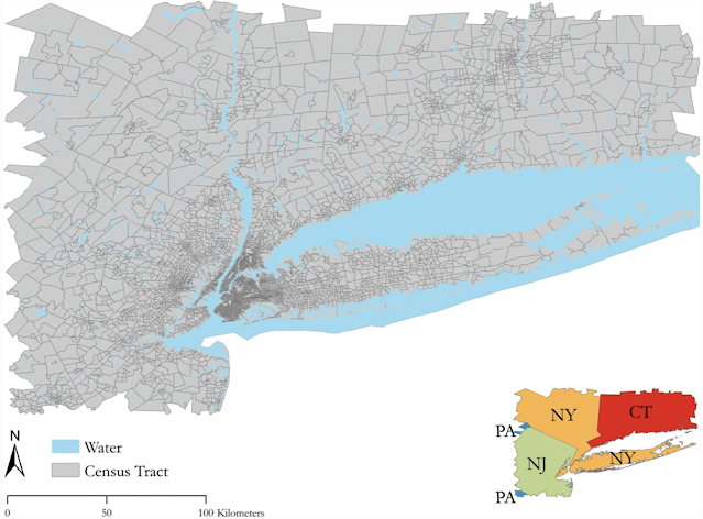
When developing geographically explicit agent-based models, one thing we spend a lot of time on is building synthetic populations and then linking the agents in the synthetic population to each other.  To overcome this issue we have a new paper published in "Computational Urban Science " entitled "A method to create a synthetic population with social networks for geographically-explicit agent-based models" In this paper  Na (Richard) Jiang, Hamdi Kavak, Annetta Burger, William Kennedy and myself present a synthetic population generation method that also includes social networks and use the New York Metro as a study site, which covers an area of 262 x 234 km and is home to over 23 million people. 

To show the utility of this method we also present three simple applications (e.g., a disease , a disaster  and a traffic model) which utilize different parts of this synthetic population but are all geographically explicit and use networks in some shape or form. If this sounds of interest, below you can read the abstract from the paper, along with seeing some of the figures from our methodology and example applications. While at the bottom of the post we provide the full citation and a link to the paper. The paper itself also has links to actual code that generates the synthetic population and the resulting datasets and models  (code: https://bit.ly/SynPopABM; source and resulting synthetic population data: https://osf.io/3vsaj/) .  

Abstract: 

Geographically-explicit simulations have become crucial in understanding cities and are playing an important role in urban science. One such approach is that of agent-based modeling which allows us to explore how agents interact with the environment and each other (e.g., social networks), and how through such interactions aggregate patterns emerge (e.g., disease outbreaks, traffic jams). While the use of agent-based modeling has grown, one challenge remains, that of creating realistic, geographically-explicit, synthetic populations which incorporate social networks. To address this challenge, this paper presents a novel method to create a synthetic population which incorporates social networks using the New York Metro Area as a test area. To demonstrate the generalizability of our synthetic population method and data to initialize models, three different types of agent-based models are introduced to explore a variety of urban problems: traffic, disaster response, and the spread of disease. These use cases not only demonstrate how our geographically-explicit synthetic population can be easily utilized for initializing agent populations which can explore a variety of urban problems, but also show how social networks can be integrated into such populations and large-scale simulations.

Keywords: Synthetic Population Generation, Agent-Based Modeling, New York, Traffic Dynamics, Disease, Disaster

Study Area

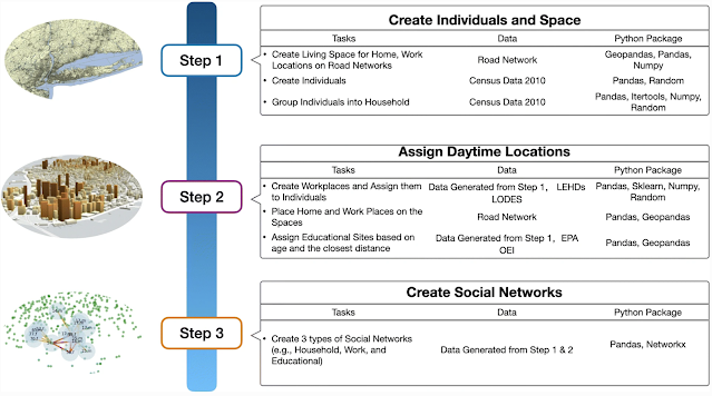
Workflow for Generation of Synthetic Population and Networks

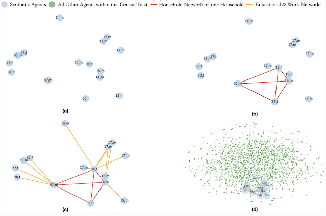
Creation of Social Networks: (a) Selected Population; (b) Creation of a Household Network; (c) Creation of Work and Educational Networks for each Member of the Household; (d) The Household, its Networks within the Full Census Tract

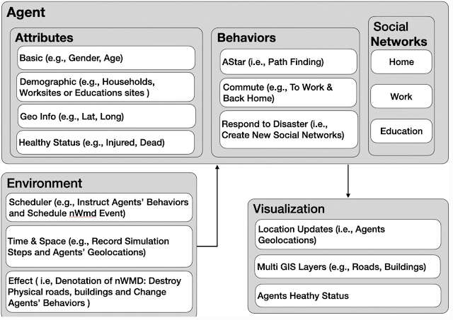
Model Component Structure of Population Respond to Disaster event

Agents’ Health Status After 1 Minute of the Disaster Event

Full Reference:

Jiang, N., Crooks, A.T., Kavak, H., Burger, A. and Kennedy, W.G. (2022), A Method to Create a Synthetic Population with Social Networks for Geographically Explicit Agent-Based Models, Computational Urban Science, 2:7. Available at https://doi.org/10.1007/s43762-022-00034-1

Friday, July 30, 2021

Generation of Reusable Synthetic Population and Social Networks

Building on our work on synthetic populations, Na (Richard) Jiang, Bill Kennedy, Hamdi Kavak, and myself have a new paper which was presented at the 2021 Annual Modeling and Simulation (ANNSIM) Conference entitled "Generation of Reusable Synthetic Population And Social Networks for Agent-Based Modeling." Rather than go into details about the paper, below is the abstract and as the conference was virtual, the presentation which accompanies the paper was prerecorded by Richard and is embedded below. If you want to find out more, at the bottom of the post there is a link to a draft of the paper.

Abstract: Within agent-based models, agents interact with each other (e.g., social networks) and their environment, and it is through such interactions more aggregate patterns emerge (e.g., disease outbreaks, traffic jams). While the popularity of agent-based modeling has grown, one challenge remains, that of creating and sharing realistic synthetic populations which incorporate social networks. To overcome this challenge, this paper introduces a new approach that creates a reusable synthetic population using the New York Metro Area as a study area. Our method directly incorporates social networks (i.e., connections within a family or workplace) when creating a synthetic population. To demonstrate the utility and reusability of the synthetic population and to highlight the role of social networks, we show two example applications: traffic dynamics and the spread of a disease. These applications demonstrate how our synthetic population method can be easily utilized for different modeling problems. 

Keywords: Synthetic Population, Agent-Based Modeling, New York, Traffic Dynamics, Disease Models.


  Full Reference: 

Jiang, N., Crooks, A.T., Kennedy, W.G., and Kavak, H. (2021), Generation of Reusable Synthetic Population And Social Networks for Agent-Based Modeling, in  Martin, C.R.,  Blas, M.J. and Psijas, A.I (eds.), Proceedings of the 2021 Annual Modeling and Simulation Conference (ANNSIM), Online, pp. 1-12.. (pdf)

Tuesday, November 03, 2020

Integrating Social Networks into Large-scale Urban Simulations

Building on past posts about our work with respect to generating large scale synthetic populations for agent-based models, we have a new paper entitled "Integrating Social Networks into Large-scale Urban Simulations for Disaster Responses" that was accepted at the 3rd ACM SIGSPATIAL International Workshop on GeoSpatial Simulation. In the paper we discuss our method to create synthetic populations  which incorporates social networks to generate for the New York megacity region. To demonstrate the utility of our approach, we use the generated synthetic population to initialize an agent-based model which not only generates basic patterns of life (e.g., commuting to and from work), but also allows us to explore how people react to disasters and how their social networks are changed by such events. 

If sounds of interest to you, below we provide the abstract to the paper, along with our synthetic population workflow and some sample outcomes from the model. At the bottom of the post we provide the full reference and link to the paper (the paper itself also links to a GitHub repository where more information about the synesthetic population can be found).

ABSTRACT: Social connections between people influence how they behave and where they go; however, such networks are rarely incorporated in agent-based models of disaster. To address this, we introduce a novel synthetic population method which specifically creates social relationships. This synthetic population is then used to instantiate a geographically explicit agent-based model for the New York megacity region which captures pre- and post- disaster behaviors. We demonstrate not only how social networks can be incorporated into models of disaster but also how such networks can impact decision making, opening up a variety of new application areas where network structures matter in urban settings. 

KEYWORDS: Urban Simulation, Agent-based models, Synthetic Populations, Social Networks, Geographical Information Systems, Disasters.

Synthetic population and social network generation workflow.
Synthetic population at household level within a census track (A) and social network of one individual (B).
Example of a heat-map of traffic density (A) Manhattan is center of the plot. The impact area of the disaster and the health status of the agents (B).

Full Reference:

Jiang, N., Burger, A., Crooks, A.T. and Kennedy, W.G. (2020), Integrating Social Networks into Large-scale Urban Simulations for Disaster Responses. Geosim ’20: 3rd ACM SIGSPATIAL International Workshop on GeoSpatial Simulation, Seattle, WA. (pdf)

Saturday, October 07, 2017

Generation of Realistic Mega-City Populations and Social Networks for ABM


At the upcoming 2017 Annual conference of the Computational Social Science Society of the Americas, Annetta Burger, Talha Oz, William Kennedy and myself have a paper entitled: "Generation of Realistic Mega-City Populations and Social Networks for Agent-Based Modeling". 

In the paper we discuss some of our current work of generating synthetic human populations with realistic social networks with respect to the New York mega-city and surrounding region. Below you can read the abstract of the paper and see our workflow along with some initial results. The full reference to the paper and a link to the pdf can be found at the bottom of the post.


Abstract:
Agent-based modeling is a means for researchers to conduct large-scale computer experiments on synthetic human populations and study their behaviors under different conditions. These models have been applied to questions regarding disease spread in epidemiology, terrorist and criminal activity in sociology, and traffic and commuting patterns in urban studies. However, developing realistic control populations remains a key challenge for the research and experimentation. Modelers must balance the need for representative, heterogeneous populations with the computational costs of developing large population sets. Increasingly these models also need to include the social network relationships within populations that influence social interactions and behavioral patterns. To address this we used a mixed method of iterative proportional fitting and network generation to build a synthesized subset population of the New York megacity and region. Our approach demonstrates how a robust population and social network relevant to specific human behavior can be synthesized for agent-based models. 

Keywords: Agent-based Models, Geographical Systems, Population Synthesis, Social Networks, Megacity.


Full Reference: 
Burger, A., Oz, T., Crooks, A.T. and Kennedy, W.G. (2017). Generation of Realistic Mega-City Populations and Social Networks for Agent-Based Modeling, The Computational Social Science Society of Americas Conference, Santa Fe, NM. (pdf)


Thursday, September 19, 2013

U.S. Synthetic Population Viewer


I have blogged before about a project that is creating a synthetic population for each household and person in the U.S. based on 2005-2009 ACS public use microdata and other data sources. Now one can view this information with an on-line viewer. Whats interesting about the viewer is that you can visually explore combinations of income, household size, and household age across the U.S. More information about the project can be found here, while the actual data can be downloaded from here.

Friday, December 14, 2012

Fusing remote sensing with demographic data for synthetic population generation

When building agent-based models related to "real" world locations and people, the challenge is to build agents which resemble people on the ground. I have blogged about microsimulation approaches before and their utility with respect to agent-based models. A new paper in the International Journal of Geographical Information Science by alumnae from the Department of Computational Social Science here at GMU have developed a new algorithm which could prove useful. Below is abstract of the paper:
We develop a new algorithm for population synthesis that fuses remote-sensing data with partial and sparse demographic surveys. The algorithm addresses non-binding constraints and complex sampling designs by translating population synthesis into a computationally efficient procedure for constrained network growth. As a case, we synthesize the rural population of Afghanistan, validate the algorithm with in-sample and out-of-sample tests, examine the variability of algorithm outputs over k-nearest neighbor manifolds, and show the responsiveness of our algorithm to additional data as a constraint on marginal population counts.

Full Reference:

Rizi, S.M.M., Łatek, M.M. and Geller, A. (2012), 'Fusing Remote Sensing with Sparse Demographic Data for Synthetic Population Generation: An Algorithm and Application to Rural Afghanistan', International Journal of Geographical Information Science, DOI:10.1080/13658816.2012.734825.


Thursday, May 31, 2012

Synthetic population data for the U.S

When creating agent-based models, one question is how many agents to include and where are they located.  Often we create synthetic individuals or households based on census data however, this can be a rather time consuming task. So a recent project from RTI has caught my attention. It is a  U.S. wide geospatially explicit synthetic population funded under a grant from NIH/NIGMS. 

The dataset provides a synthetic version of each household and person in the U.S. based on 2005-2009 ACS public use microdata and other sources.  LandScan 90-meter night-time population distributions were used to place each household across the landscape (a total of 112,383,675).

The basic website location for information and to download the data is at: https://www.epimodels.org/midas/pubsyntdata1.do 

Another short write up can be found here: http://www.openabm.org/forum/2852

Wednesday, January 06, 2010

Dynamic Modeling in a GIS Environment Seminars Online

Just a quick post to highlight that the presentations from the "Dynamic Modeling in a GIS Environment" Virtual Seminars from the Global GIS Academy are now availble online. For those interested in GIS and various aspects of modelling these seminars give a glimpse into some current research.

Also if you like to look at online seminars the 2008 Autumn seminar series on Neogeography is also available.

Tuesday, March 10, 2009

Challenges and Visions in the Social Sciences

I just come across a very interesting site from the 2008 International Workshop on Challenges and Visions in the Social Sciences organised by Dirk Helbing, Lars-Erik Cederman, Andreas Diekmann, Frank Schweitzer and Didier Sornette. The reason I am blogging about it is that there are over 20 talks available on-line (including slides) identifying future trends in the social sciences, and problems that will have to be addressed. Talks include:

Such a resource should be of interest for anyone interested in computational social science. A short report summarising the workshop can be found here. Which includes: modelling and simulation challenges such as parameter calibration, correlation and causality, Realistic vs. toy models. Along with challenges associated with interdisciplinary research such as the use of terminology, networking and cooperation, information exchange and publication.


Tuesday, January 13, 2009

CASA S4 Modelling Tour Workshop


Last week CASA hosted a two day workshop showcasing our work along with researchers from the University of Leeds as part of the of the S4 European Spatial Analysis network modelling tour. Over 150 people both from the public and private sector came to the event from all across Europe. The first day of the event was designed to showcase CASA's use of new technologies for mapping and visualizing information about cities and was entitled "Geographic Information in a Web-Based World."

Talks ranged from introducing GMapCreator and MapTube which enable web-based mapping for sharing and visualising geographic information, to public engagement via the London Profiler, Public Profiler and the E-Society Classification websites. The geography and ethnicity of people's names was explored which introduced the WorldNames and Onomap websites.

Other talks on the first day explored the use of MapTube and GMapCreator for Crowdsourcing near-real time spatial surveys and understanding crowdsourced geographical information via the analysis of OpenStreetMap. On a more data oriented side, there were talks on exploring urban data collection and mapping, analysing and visualising fine scale urban form and socio-economic datasets. The day concluded with a talk by Andrew Hudson-Smith from Digital Urban on Web 2.0 and neogeography in real and virtual spaces: from geocaching through to Second Life.


The second day of the workshop was entitled "Developments in Urban Models, Simulation and Spatial Analysis" and talks ranged from: rank clocks and scaling in city sizes, geodemographics, retail modelling, the need to capture urban form patterns and processes in agent-based models, pedestrian modelling, consumer behaviour, microsimulation and 3D visualisation and communication of agent-based models.


Click here to see the full program and to download the presentations.

Add Image

Wednesday, November 07, 2007

Matsim

A previous post introduced the notion of microsimulation and how it can be integrated with ABM. As a follow on to this post, I would like to draw ones attention to such an application. That of MATSim (Multi Agent Traffic Simulation),n open source java application which links diverse datasets such as networks (e.g. roads and public transport networks), population data (e.g. census data and commuter matrices) and demand (places of work, leisure facilities, opening hours) and uses this information to simulated a range of issues. From that of road pricing schemes, location based services, city evacuation and social networks.

Basically MATSim provides a toolbox to implement large-scale agent-based transport simulations. The toolbox consists of several modules which can be combined or used in stand-alone applications. Currently, MATSim offers a toolbox for demand-modelling, mobility-simulation, re-planning, a controller to iteratively run simulations as well as methods to analyze the output generated by the modules.

MATSim is currently being developed by two groups: Transport Planning at the Institute for Transport Planning and Systems (IVT), Swiss Federal Institute of Technology Zurich, and the Transport Systems Planning and Transport Telematics at the Institute for Land and Sea Transport Systems, Technische Universität Berlin.

MATSim can be download from http://sourceforge.net/projects/matsim while further information and links about MATSim can be found on the Project website.

An alternative to MATSim is TRANSIMS, and Balmer, et al. 2005 provide a comparison of MAtSIM with TRANSIMS.


Thursday, October 18, 2007

Microsimulation


Often within ABM one wants to model the individual and how these individuals interact to form emergent patterns such as individuals and the resulting crowd or popupulations. The problem is the lack of data at the individual level. One potential solution to this is combing microsimulation and agent-based modelling techniques.

The foundations of microsimulation as a technique for socio-economic modelling was pioneered by Orcutt (1957) who identified and represented individual actors in the economic system through the way in which their behaviour changed over time. However, early adoption of this technique for socio-economic modelling was hindered by the limited computer resources and lack of data about temporal behaviour.

Today, microsimulation provides one of the most disaggregated techniques for urban modelling. The main features of microsimulation can be found in a paper by Clarke and Holm (1987) which additionally reviews its early applications in economics, healthcare planning and demographics. The basic concept is simply to represent the elementary units (of a city or region) be it a person, a house or a car as a set of individuals objects with unique characteristics rather than using aggregate counts such as output areas from the census. This is often achieved by generating a synthetic population to represent imaginary rather than real people using aggregate data. In such a way those particular characteristics are associated with a particular individual, so that the distributions of the simulated population match the real or modelled distributions (as a way of building artificial populations which closely resemble actual societies). Once the individuals have been created in this way, the model is used for some purpose such as policy analysis.

Microsimulation models can be both dynamic and static in nature and have been applied to disciplines associated with urban and regional analysis especially for the analysis of policy impact. Early efforts in particular focused on the sociology, economics, social administration (e.g. healthcare provision), housing and residential location (see Holm et al., 2000 and Wilson, 2000 for further details and reviews; additionally the International Microsimulation Association provides links to models under active development). The models are often used to simulate changes in distribution, for example, demographic and land-use changes (as in UrbanSim) or the distribution of traffic flow over a street network (e.g. as in the TRANSIMS model, see Waddell, 2001) and are the basis for many popular planning support systems.

While early microsimulation modelling efforts where not overtly spatial as they were often developed outside the field of geography, with the advent of more comprehensive datasets, more powerful computing technology and the development of GIS, microsimulation models now have the ability to represent spatial processes explicitly. For example at the University of Leeds, an explicit and detailed spatial dimension has been added to microsimulation models, including the coupling with spatial interaction models (e.g. Birkin and Clarke, 1987, cited in Birkin, 2005; Clarke and Holm, 1987) and its integration with GIS. Microsimulation models at Leeds have been applied to domains such as education, health, labour markets and retailing (see Birkin, 2005 for further details). In particular, the MoSeS (Modelling and Simulation for e-Social Science) project from the University of Leeds aims to develop a demographic simulation at the level of individuals and households to give robust forecasts of the future population of the UK (Birkin et al., 2006) For more information on MoSeS click here).

Microsimulation provides a mechanism to evaluate the effects of policy changes at the level of the decision making units such as individuals, firms and households rather than focusing on the aggregate information of groups of individuals to predict policy impacts, while at the same time estimates of aggregate outcomes can still be derived by summing up individual predictions. Whilst this process of creating individuals based on aggregate data addresses the ecological fallacy of assigning average group attributes to individual entities, and assuming an ecological correlation between them, it does not address the Modifiable Areal Unit Problem (MAUP) of decomposing aggregate spatial data arbitrarily into smaller geographical units (Benenson and Torrens, 2004).

Another important question concerns the relationship between microsimulation and agent-based modelling for urban modelling. While both approaches focus on the individual, the two approaches are different. For example, Birkin (2005) writes that it may be fair to characterise agent-based approaches as mostly concerned with behaviour at the individual level, while microsimulation as concerned with questions of composition and structure of the urban area. In traditional ABM, the emphasis is on interaction between individuals based on behavioural rules, which evolve stochastically over time and space in response to the interactions with other individuals, while traditional microsimulation transition probabilities lack evolutionary and spatial dimensions.

On the other hand, the two approaches are moving towards a more common ground as microsimulation models add more behavioural and spatial interaction between individual units and ABM add both space and demographic characteristics to their agents (The International Microsimulation Association, 2006). For example, TRANSIMS is an agent-based model using disaggregate microsimulation techniques to simulate traffic for large metropolitan areas, and the ILUTE (Integrated Land-use, Transportation Environment) model is an agent-based model which examines land-use and transportation within a metropolitan area (Miller et al., 2004).

References:
Benenson, I. and Torrens, P.M. (2004), Geosimulation: Automata-Based Modelling of Urban Phenomena, John Wiley ANDSons, London, UK.
Birkin, M. (2005), 'Retail and Service Location Planning', in Maguire, D.J., Batty, M. and Goodchild M, F. (eds.), GIS, Spatial Analysis and Modelling, ESRI Press, Redlands, CA, pp. 221-244.
Birkin, M. and Clarke, M. (1987), 'Comprehensive Models and Efficient Accounting Frameworks for Urban and Regional Systems', in Griffith, D. and Haining, R. (eds.), Transformations Through Space and Time, Martinus Nijhoff, The Hague, Netherlands, pp. 169-195.
Birkin, M., Turner, A. and Wu, B. (2006), 'A Synthetic Demographic Model of the UK Population: Methods, Progress and Problems', Regional Science Association International British and Irish Section, 36th Annual Conference, Jersey, Channel Islands.
Clarke, M. and Holm, E. (1987), 'Microsimulation Methods in Spatial Analysis and Planning', Geografiska Annaler. Series B, Human Geography, 69(2): 145-164.
Holm, E., Lindgren, U. and Malmberg, G. (2000), 'Dynamic Microsimulation', in Fotheringham, A.S. and Wegener, M. (eds.), Spatial Models and GIS: New Potential and New Models, Taylor and Francis, London, UK, pp. 143-165.
Miller, E.J., Hunt, J.D., Abraham, J.E. and Salvini, P.A. (2004), 'Microsimulating Urban Systems', Computer, Environment and Urban Systems, 28(1-2): 9-44.
Orcutt, G.H. (1957), 'A New Type of Socio-Economic System', Review of Economics and Statistics, 39(2): 116-123.
The International Microsimulation Association (2006), What is Microsimulation?, Available at http:www.microsimulation.org [Accessed on 18th Oct, 2007].
Wilson, A.G. (2000), Complex Spatial Systems: The Modelling Foundations of Urban and Regional Analysis, Pearson Education, Harlow, UK.
Waddell, P. (2001), 'Between Politics and Planning: UrbanSim as a Decision-Support System for Metropolitan Planning', in Brail, R.K. and Klosterman, R.E. (eds.), Planning Support Systems: Integrating Geographic Information Systems, Models and Visualisation Tools, ESRI Press, Redlands, CA, pp. 201-228.