
GAL files are used in the Repast when using OpenMap. GAL stands for GenePix Array List and which provides an easy way to link between location and the quantitative values that represent each agent (polygon). Basically it is a text file with specific information and used within the program to create an array list. They are easily created using VB in ArcGIS. The GAL file contains information about the number of polygons In the case below it is 0 to 6(the last polygon in the list), the file name (all_data_small) and the column name (ID_ID) where the polygon id can be found (See diagram below). Alternatively can be created using GeoDa, a freely downloadable program designed to implement techniques for exploratory spatial data analysis (ESDA) on lattice data (points and polygons).
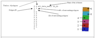
An annotated example of a .GAL file and the associated shapefile with the polygons numbered accordingly.
No comments:
Post a Comment