Simulating past, present, and future events can empower humans to understand the composition and interactions in complex systems and explain their emergence and evolution from bottom up. In practice, geosimulations constitute a powerful tool in engaging different stakeholders, exploring what-if scenarios, and evaluating alternative policy outcomes.
We invite interdisciplinary works for the exploration and understanding of complex social and environmental processes by means of computer simulation. We focus on all aspects of simulation and agent societies, including multi-agent systems, agent-based modeling, microsimulation, artificial intelligence (AI) agents, and the integration of Generative AI with simulation.
As GenAI is impacting all aspects of our lives, we are wondering how it will impact geospatial simulations. How do multimodal large language models (MLLMs) help with agent-decision making in the form of generating agent-personas or scheduling agent activities? Can MLLMs reduce coding barriers for beginners? Will GenAI lead to a new generation of modeling toolkits? What are the challenges brought by MLLMs in model design, validation, and computing costs?
We welcome a wide range of studies exploring simulation theories, data, methodologies, and frameworks. We are also interested in case studies applying geosimulations to address real-world challenges. Potential topic areas include, but are not limited to:
Geosimulation Models and Applications
Conceptual Geosimulation Models
General-Purpose Geosimulation Framework
AI and Geosimulation
Agents’ Behaviors, Decision-making and AI Agents
Data Generation Framework
Validation and Verification for Geosimulation
Digital Twins
Microsimulation
Multi-agent Systems
If you are interested, please email your title and 250-word abstract to Fuzhen Yin (fyin@uccs.edu) and Jeon-Young Kang (geokang@khu.ac.kr) by October 30th.
Chairs:
Fuzhen Yin, University of Colorado Colorado Springs
In this poster and extended abstract we detail how LLMs can help with many aspects of agent-based modeling development. If this sounds of interest, below you can see the abstract, the poster and the full referece and link to the extended abstract .
Abstract:
Large language models (LLMs) play an important role in AI-powered code assistants such as code completion, debugging, and documentation. Such models can be further fine-tuned on smaller amount of data for specific tasks, often with the improvement of performance compared to generic LLMs. However, such fine-tuning techniques are seldomly used in generating sophisticated agent-based models (ABMs), because they are often implemented as software that demands extra standards such as the Overview, Design concepts, and Details (ODD) protocol. This research examines how we can bridge this gap by utilizing LLMs in designing or conceptualizing, building, and running agent-based models in the form of user prompts. In this work, two models are created to demonstrate the proposed method. Specifically, Sakoda's checkerboard model of social interaction is created by LLM from explicit design and description through prompts. The other model stimulates consumer preferences and restaurant visits as designed and implemented by a LLM. These models are evaluated by human experts on their code correctness and quality for both verification and validation purposes. This work serves as a first step towards fine-tuned LLMs on existing models and documentations to create high-quality and functional ABMs based on either user prompts or standard protocols, contributing to further exploration on the future of AI-assisted geospatial simulation development.
Keywords: agent-based modeling, geospatial simulations, large language models, generative AI, coding
Full reference:
Jiang, N., Wang, B. and Crooks, A.T. (2025), Agent-based Models with Large Language Models: Two Modeling Examples, 11th International Conference on Computational Social Science (IC2S2), 21-24th July, Norrkoping, Sweden. (extended abstract pdf) (poster pdf)
For example, in the editorial we discuss how GenAI could speed up the overall urban modeling process. To demonstrate this we show how ChatGPT (and its built-in coding interface Canvas) can take published papers and build agent-based models from them (one being of an abstract space and another being spatially explicit).
However, while model building is time consuming task, another challenge modelers face is how to incorporate decision making within them. To this end we also discuss how large language models (LLMs) have the potential to help with agent-decision making in the form of generating agent-personas or scheduling agent activities.
We conclude the editorial with a series of questions: how will GenAI impact urban modeling? Will it open up the field to more people without the need for strong coding skills? Will we see growth in using LLMs for generating behavior? Will GenAI lead to a new generation of modeling toolkits? While these are only a short list of questions, they also raise concerns that relate back to some of the more thorny issues of urban modeling, that of verification and validation.
If this sounds of interest you can read the full editorial here.
As the AAG has just wrapped up I thought I would write brief (well actually quite long) post on the talks that I was involved with at the conference. These talks would not have been possible without the many great students and colleagues who I have been collaborating with over time. Below you will find a brief summary of the talks and if any sound interesting, please reach out and we can give you more details.
First up (in order in which they were presented) was "Utilizing Streetview Images for Mapping Building Attributes with ChatGPT" with Qingqing Chen and Linda See. In this talk we discussed how multimodal Large Language Models are giving us a new way to study cities, in the sense, lowering the boundary for information extraction. Using ChatGPT andstreet view images from Mapillary as an example, we showed how one can extract building age, usage (e.g., commercial, mixed use, residential) and estimate building height which could all be used to inform urban climate models which require detailed information on buildings.
Abstract:
With increasing rates of urbanization, many challenges are emerging regarding sustainability such as the energy usage of buildings. Coinciding with this is the growing attention of urban climate models for energy demand estimation and climate adaptation strategies. However, the applicability of these models is constrained by the lack of detailed urban surface information. Therefore, creating comprehensive datasets that capture urban surface information at a granular scale is crucial for responding to our rapidly urbanizing world. Recent advancements in Large Language Models (LLMs) have opened new opportunities in urban studies, offering accessible methods for information extraction. In this talk we explore the feasibility of ChatGPT to extract building attributes from images. Taking New York City as a case study, we collect building images from Mapillary and process them through ChatGPT by posing specific questions to extract building attributes (e.g., height, functions, age). These attributes are then compared with authoritative data. The proposed method helps address the current dearth of fine-grained surface data on urban issues, therefore enhancing the accuracy and utility of urban climate models. Overall, this study demonstrates the practical applications of ChatGPT in geographic knowledge extraction, advancing the understanding of LLMs in geographic contexts, and more broadly to the discourse on Artificial Intelligence (AI) in urban modeling and climate science.
Keywords: Buildings, ChatGPT, Large Language Models (LLMs), Mapillary, Street View Images (SVI), GeoAI.
Example of Workflow.
Reference:
Chen, Q., See, L. and Crooks, A.T. (2025), Utilizing Streetview Images for Mapping Building Attributes with ChatGPT, The Association of American Geographers (AAG) Annual Meeting, 24th –28th March, Detroit, MI. (pdf)
This was followed by a talk by lead by Qingqing Chen entitled "Multi-sensory Experiences: The Connection Between the Smell and Vision in Understanding Urban Environments" where we explored to what extent can visual data from street view imagery be used as a proxy for capturing large-scale urban smell perceptions when compared to geosocial media. Such as what visual cues evoke specific smell perceptions.
Abstract:
Smell is a crucial transversal sense, which bridges the tangible aspects of urban environments, such as exhaust and garbage, with their intangible impacts on emotions, social interactions and well-being. Despite its crucial role in our everyday life, many urban studies primarily focus on the visual dimension, potentially introducing biases in our understanding of urban spaces. This research transcends this visual-centric bias by integrating the olfactory perceptions to investigate the nuanced relationship between smell and vision in urban environments. Specifically, we utilize advanced semantic segmentation to extract visual elements from street view imagery (i.e., Mapillay) and apply casual forest analysis to examine their causal effects on smell expectations recorded from human participants. These expectations, often tied to personal experiences and/or cultural associations, are compared with real-environment smell experiences derived from geosocial media (i.e., Twitter/X). The results show that visual cues can predict smells in straightforward urban settings, such as small parks or less densely populated areas. However, in complex urban environments, the predictive power of visual cues diminishes as diverse and overlapping scents obscure specific smells, even in visually distinct areas. These findings underscore the importance of a multisensory approach in urban studies, enhancing our understanding of the complex interplay between sensory experiences and informing urban design strategies that integrate multiple senses to create more engaging and inclusive environments. This is especially important for individuals with sensory impairments, such as anosmia or visual impairments, who rely on other senses to compensate for their perception of urban environments.
Keywords: Multi-sensory Experiences, Smell and Vision; Semantic Segmentation, Causal Effects, Geosocial Media, Street View Imagery (SVI).
Workflow
Reference:
Chen, Q. and Crooks, A.T. (2025), Multi-sensory Experiences: The Connection Between the Smell and Vision in Understanding Urban Environments, The Association of American Geographers (AAG) Annual Meeting, 24th –28th March, Detroit, MI. (pdf)
In the Geosimulation session that we organized, we had a talk entitled "Large Language Models for Conceptualizing, Designing, and Generating Agent-based Models" where Na Jiang, Boyu Wang and myself presented our work on exploring using multimodal Large Language Models (LLMs) to create age-based models. In the sense as modelers, we spend a lot of time developing and writing code and we were curious what could be done though the use of LLMs.
To give a sense of what is possible, below is an example of using ChatGPT for creating a model from a published paper.
Abstract:
Large language models (LLMs) play an important role in AI-powered code assistants such as code completion, debugging, and documentation. Such models can be further fine-tuned on smaller amount of data for specific tasks, often with the improvement of performance compared to generic LLMs. However, such fine-tuning techniques are seldomly used in generating sophisticated agent-based models (ABMs), because they are often implemented as software that demands extra standards such as the “Overview, Design concepts, and Details” (ODD) protocol. This research examines how we can bridge this gap by utilizing LLMs in designing or conceptualizing, building, and running agent-based models in the form of user prompts. . In this work, two models are created to demonstrate the proposed method. Specifically, Sakoda’s checkerboard model of social interaction is created by LLM from explicit design and description through prompts. The other model stimulates consumer preferences and restaurant visits as designed and implemented by a LLM. These models are evaluated by human experts on their code correctness and quality for both verification and validation purposes. This work serves as a first step towards fine-tuned LLMs on existing models and documentations to create high-quality and functional ABMs based on either user prompts or standard protocols, contributing to further exploration on the future of AI-assisted geospatial simulation development.
Keywords: Agent-Based Modeling, Large Language Models, Geospatial Simulation
Reference:
Jiang, N., Wang, B. and Crooks, A.T. (2025), Large Language Models for Conceptualizing, Designing, and Generating Agent-based Models, The Association of American Geographers (AAG) Annual Meeting, 24th –28th March, Detroit, MI. (pdf)
Next up was Ying Zhou who presented our work entitled "Identifying Environmental Characteristics That Influence Perceived Safety in Urban Spaces." In this work we explored how using social media data can be used to study the fear and how this relates to actual crimes within New York city. Broadly speaking we find through our analysis, that fear sentiment may spread out between the neighborhoods and their surrounding areas and that neighborhoods surrounded by crime-clusters may have high sentiments of fear.
Abstract:
One goal of creating livable cities is to enhance health and safety. While previous research in spatial analysis and urban planning has focused on correlations between physical environments and crime, typically relying on police-reported crime data from sources like the Crime Open Database (CODE), safety perception is inherently subjective and cannot be fully represented by objective crime statistics alone. Also, urban planning today has gradually shifted its focus from a top-down mechanism to a bottom-up mechanism, so understanding and fostering spaces where residents feel safe is essential. This research examines factors that contribute to residents’ perceived insecurity in New York City. In addition to spatial analysis of the open crime data, the research used social media data to acquire people’s perceptions. The result indicates that the aggregations of perceived unsafe locations overlapped with aggregations of crime data's locations, such as in Manhattan’s neighborhoods, but they do not overlap with each other entirely. By adopting Latent Dirichlet Allocation (LDA), a method of topic modeling, the research filtered and summarized the posted texts and contents related to the negative descriptions of places or spaces in the city, and then it identified the related characteristics of the environments. The characteristics are investigated by the method of local Moran’s I, which indicates their spatial autocorrelation in some neighborhoods in the city of New York. This research offers “bottom’s views” about urban safety for both urban planning and decision-makers, which contributes to people-centered consideration for future development and urban resource distribution.
Zhou, Y. and Crooks, A.T. (2025), Identifying Environmental Characteristics That Influence Perceived Safety in Urban Spaces, The Association of American Geographers (AAG) Annual Meeting, 24th –28th March, Detroit, MI. (pdf)
The last day of the conference was another busy day with two talks. First was entitled "PySGN: A Python Package for Constructing Synthetic Geo-social Networks" where Boyu Wang presented our work (with Taylor Anderson and Andreas Züfle) on a Python package that can be used to generate synthetic geo-social networks. As readers of this blog might know we have a an interest in social networks and using them in modeling and this package provides a toolkit for others to easily create their own geosocial networks (e.g., Geospatial Erdős-Rényi, Barabási–Albert and Watts-Strogatz models). For interested readers, the source code available at: https://github.com/wang-boyu/pysgn.
Abstract:
Synthetic population has been widely used in social simulations such as traffic modeling, pedestrian movements, and the spread of infectious diseases. In recent years, much attention was focused on generating synthetic population with social networks, that captures social connections between individuals. While synthetic populations are often geographically explicit, various algorithms have been proposed to create realistic geographic social (geo-social) networks, aiming to integrate spatial information into people’s social links. We build an open-source Python package, namely PySGN, for constructing synthetic geo-social networks that incorporates position information, exhibits small-world network properties, and can be scaled to hundreds of thousands and potentially millions of nodes. We discuss different ways of parametrizing the method, by either a global average node degree, or an expected degree for each individual node. It is demonstrated through a case study with synthetic population in Buffalo, NY. By doing so, we aim to illustrate how such synthetic geo-social networks can be created, utilized, and analyzed in downstream agent-based modeling and network analysis tasks. This work is available as an open-source Python package and integrated with the PyData ecosystem (e.g., GeoPandas, NetworkX), and can be further extended with more synthetic geo-social network algorithms in the future.
Wang, B., Crooks, A.T., Anderson, T. and Züfle, A. (2025), PySGN: A Python Package for Constructing Synthetic Geo-social Networks. The Association of American Geographers (AAG) Annual Meeting, 24th –28th March, Detroit, MI. (pdf)
The final talk (well for me) was presented by Fuzin Yin who presented our work with Lucie Laurian and Emmanuel Frimpong Boamah entitled "Analysis of Online Mutual Aid Network during Buffalo Blizzard 2022: Actors and Weak Ties." In this work we explored what kind of support was offered and requested over Facebook groups along with their network structures durring and shortly after the event utilizing machine learning.
Abstract:
In December 2022, Buffalo, NY encountered a once-in-a-generation blizzard that dropped over 4 feet of snow. This four-day snow event halted emergency services and left 47 dead. In the face of the devastating blizzard, Buffalonian demonstrated resilience and solidarity by establishing Facebook (FB) groups to share information and coordinate behaviors including donations, wellness checks, and snow removals. These spontaneous behaviors created an essential layer of protection when the major infrastructure was down. This research has collected data from Buffalo blizzard FB groups to analyze community-led self-help behaviors. We have used machine learning to classify FB messages into four categories (e.g., requesting help, offering help, emotional support, and other), and social network analysis to explore users’ communication patterns. Results show that out of all messages (n=9,988), 37% of them express emotional support, which is followed by messages offering help (25%). While requests for help constitute a small proportion (8%), they stimulate more replies than other categories. Network statistics suggest that the mutual aid network is low-density but with a high clustering coefficient. This implies that most group members are strangers with weak ties, but their connections are in the right place to allow efficient communication. However, users do not equally benefit where people requesting or offering help are central in online conversation while pure emotional supporters are at the periphery. We conclude that during the Buffalo blizzard 2022, online interactions translate into offline mutual assistance by establishing weak ties among disconnected users to facilitate the flow of information and resources.
Keywords: crisis informatics, mutual aid, social network analysis, machine learning, social media
Results of Mutual Aid Network during Buffalo Blizzard 2022
Reference:
Yin, F., Laurian, L., Crooks, A.T. and Boamah, E.F. (2025), Analysis of Online Mutual Aid Network during Buffalo Blizzard 2022: Actors and Weak Ties, The Association of American Geographers (AAG) Annual Meeting, 24th –28th March, Detroit, MI. (pdf)
While this is a rather longer post than normal, we hope you found it interesting and also as noted at the top of the post, if any of these talks/topics are of interest to you please feel free to reach out.
We are delighted to announce a special track on “Integrating Large-Language Models and Geospatial Foundation Models to Enhance Spatial Reasoning in ABMs” as part of the Social Simulation Conference 2025, 25th to 29th August 2025 at Delft University of Technology, the Netherlands. Full conference details can be found at the end of this email.
Abstract for the Special Track:
Recent developments in the use of large language models (LLMs) offer exciting opportunities to control agent behaviour in potentially more realistic and nuanced ways than has previously been possible. However, an LLM-backed agent can only interface with their surroundings through text prompts, which is severely limiting. The integration of large language models (LLMs) and geospatial foundation models (GFMs) presents an exciting opportunity to use AI techniques to advance agent-based modelling for spatial applications, potentially allowing for agents with more comprehensive behavioural realism, as well as an improved perception of their environment.
This special track invites papers that explore how AI techniques, such as LLMs and GFMs, can enrich spatial agent based models, raising new questions about their feasibility in modelling human behaviour, in comparison to conventional approaches. There are huge challenges around computational efficiency, sustainability, bias, model validation, and integration frameworks, and we welcome papers that consider these issues as well.
In numerous posts, we have been discussing synthetic populations and their use in agent-based modeling. But there are many modeling styles that also utilize synthetic populations. In our own work we often spend significant amounts of time creating such synthetic populations, especially those grounded with data, due to the time needed to collect, preprocess and generate the final synthetic population. To alleviate this, we (Na (Richard) Jiang, Fuzhen Yin, Boyu Wang and myself) have a new paper published in Scientific Data, entitled "A Large-Scale Geographically Explicit Synthetic Population with Social Networks for the United States." Our aim of this paper is to build and provide a geographically explicit synthetic population along with its social networks using open data including that from the latest 2020 U.S. Census which can be used in a variety of geo-simulation models.
Summary of the Resulting Datasets.
Specially, in the paper we outline how we created the a synthetic population of 330,526,186 individuals representing America's 50 states and Washington D.C.. Each individual has a set of geographical locations that represent their home, work or school addresses. Additionally, these individuals are not isolated, they are embedded in a larger social setting based on their household, working and studying relationships (i.e., social networks).
The work (e.g., data collection, data preprocessing and generation processes) was coded using Python 3.12 and all the scripts used are available at: https://github.com/njiang8/geo-synthetic-pop-usa while the resulting datasets (85 GB uncompressed) are available at OSF: https://osf.io/fpnc2/.
To give you a sense of the paper, below we provide the abstract to it, along with some results and our efforts to validate the synthetic population. While at the full reference and link to the paper can be found at the bottom of the post.
Abstract:
Within the geo-simulation research domain, micro-simulation and agent-based modeling often require the creation of synthetic populations. Creating such data is a time-consuming task and often lacks social networks, which are crucial for studying human interactions (e.g., disease spread, disaster response) while at the same time impacting decision-making. We address these challenges by introducing a Python based method that uses the open data including that from 2020 U.S. Census data to generate a large-scale realistic geographically explicit synthetic population for America's 50 states and Washington D.C. along with the stylized social networks (e.g., home, work and schools). The resulting synthetic population can be utilized within various geo-simulation approaches (e.g., agent-based modeling), exploring the emergence of complex phenomena through human interactions and further fostering the study of urban digital twins.
Keywords: Synthetic Population, U.S. Census 2020, Agent-Based Modeling, Geo-Simulation, Social Networks.
Data Generation Workflow and Resulting Datasets.
A Sample of a Social Networks for one Household and their Home, Work and Educational Social Networks from the Generated Data.
Sample of Generated Social Networks Extracted from the City of Buffalo, New York: (a) Household; (b) Work; (c) School; (d) Daycare.
Validation of the Synthetic Population at Different Levels: (a) Population under Different 18 Age Groups; (b) Household under Different Household Types.
Full Referece:
Jiang, N., Yin, F., Wang., B. and Crooks, A.T., (2024), A Large-Scale Geographically Explicit Synthetic Population with Social Networks for the United States, Scientific Data, 11, 1204. https://doi.org/10.1038/s41597-024-03970-1 (pdf)
Building upon last year’s successful sessions related to geosimulation, were various topics and issues from across the urban, social and environmental fields and the resulting application areas. More excitingly, we are witnessing the emergence of the integration of cutting-edge techniques (e.g., machine learning and generative AI) which is energizing the geosimulation community as they offer new approaches for advancing geosimulations.
This year, the 2025 AAG Annual Meeting will take place in Detroit, Michigan from March 24 to March 28. We are continuing to organize sessions on "Geosimulations for Addressing Societal Challenges," and we encourage you to submit abstracts if this area aligns with your research interests.
Session Description:
There is an urgent need for research that promotes sustainability in an era of societal challenges ranging from climate change, population growth, aging and wellbeing to that of pandemics. These need to be directly fed into policy. We, as a Geosimulation community, have the skills and knowledge to use the latest theory, models and evidence to make a positive and disruptive impact. These include agent-based modeling, microsimulation and increasingly, machine learning methods. However, there are several key questions that we need to address which we seek to cover in this session. For example, What do we need to be able to contribute to policy in a more direct and timely manner? What new or existing research approaches are needed? How can we make sure they are robust enough to be used in decision making? How can geosimulation be used to link across citizens, policy and practice and respond to these societal challenges? What are the cross-scale local trade-offs that will have to be negotiated as we re-configure and transform our urban and rural environments? How can spatial data (and analysis) be used to support the co-production of truly sustainable solutions, achieve social buy-in and social acceptance? And thereby co-produce solutions with citizens and policy makers.
We are particularly interested in presentations that will discuss issues relating to:
Agent-based modeling and microsimulation techniques for responding to societal challenges;
Agent-based models used for policy formation;
Data driven modeling;
Utilizing machine modeling for geosimulation;
Creating really big models using exascale computation;
Model validation and assessment;
Participatory methods for agent-based modeling;
Approaches to connect and share (open source) data and models;
Revealing, quantifying, and reducing socio-economic inequalities with Geosimulation.
Next Steps:
If this sounds of interest, please e-mail the abstract and keywords with your expression of intent to Richard Jiang (njiang8@buffalo.edu) by October 29 (2 days before the AAG session deadline). Please make sure that your abstract conforms to the AAG guidelines in relation to title, word limit and keywords and as specified at: https://aag.secure-platform.com/aag2025/page/abstracts/abstract-guidelines An abstract should be no more than 250 words that describe the presentation’s purpose, methods, and conclusions.
Timeline:
October 29, 2024: Please send abstract and keywords with your expression of intent to Richard Jiang (njiang8@buffalo.edu)
October 30th, 2024: Session finalization and author notification
October 31, 2024: Final abstract submission to AAG, via https://aag.secure-platform.com/aag2025. All participants must register individually via this site. Upon registration you will be given a participant number (PIN). Send the PIN and a copy of your final abstract to Richard Jiang. Neither the organizers nor the AAG will edit the abstracts.
February 6, 2025: Final Abstract/Session Editing and Presentation Conversion deadlines for AAG, via https://aag.secure-platform.com/aag2025.
In the paper we sketch out a framework for in silico mobility data science. The rationale being in someway that mobility data alone does not tell us much about why people do what do and to quote from the paper "but imagine a world where we can go back in time to ask people about the purpose of their mobility to understand why an individual visited a place of interest." By building models (aka, agent-based models) we can do just that which therefore allows us to build in silico human mobility data
To build this argument, in the paper we review existing data sets of individual human mobility and their limitations in terms of size and representativeness. We then survey existing simulation frameworks that generate individual human mobility data and comment on their limitations before presenting our vision of a scalable in silico world that captures realistic human patterns of life and allows us to generate massive datasets as sandboxes for human mobility data science. Building off this we describe a small sample of applications and research directions that would be enabled by such massive individual human mobility datasets if our vision came true.
If this sounds of interest, below we provide the abstract to the paper, some of the figures we use to highlight our argument and our envisioned framework that could exhibit both realistic behavior and realistic movement. Finally at the bottom of the post we provide a reference and a link to the paper itself. As always, any thoughts or comments are most welcome.
Abstract:
Human mobility data science using trajectories or check-ins of individuals has many applications. Recently, we have seen a plethora of research efforts that tackle these applications. However, research progress in this field is limited by a lack of large and representative datasets. The largest and most commonly used dataset of individual human trajectories captures fewer than 200 individuals while data sets of individual human check-ins capture fewer than 100 check-ins per city per day. Thus, it is not clear if findings from the human mobility data science community would generalize to large populations. Since obtaining massive, representative, and individual-level human mobility data is hard to come by due to privacy considerations, the vision of this paper is to embrace the use of data generated by large-scale socially realistic microsimulations. Informed by both real data and leveraging social and behavioral theories, massive spatially explicit microsimulations may allow us to simulate entire megacities at the person level. The simulated worlds, which do not capture any identifiable personal information, allow us to perform “in silico” experiments using the simulated world as a sandbox in which we have perfect information and perfect control without jeopardizing the privacy of any actual individual. In silico experiments have become commonplace in other scientific domains such as chemistry and biology, permitting experiments that foster the understanding of concepts without any harm to individuals. This work describes challenges and opportunities for leveraging massive and realistic simulated alternate worlds for in silico human mobility data science.
Key Words: Spatial Simulation, Mobility Data Science, Trajectory Data, Location Based Social Network Data, In Silico
The envisioned in silico mobility data science process- (let:) A massive microsimulation is created to simulate realistic human behavior specified by a user through an AI-supported builder tool. (middle:) The microsimulation generates massive datasets, including high-fidelity trajectories of all individuals over years of simulation time. This data, which is 100% accurate and complete (in the simulated world) is then sampled to generate realistic datasets. (right:) These datasets are then used to perform mobility data science tasks in the simulated in silico world as if it was the real world. The results of these tasks can then be compared to the ground truth data (of the simulated in silico world) for validation.
Envisioned framework for a simulation that exhibits both realistic behavior and realistic movement.
Full reference:
Züfle, A., Pfoser, D., Wenk, C., Crooks, A.T., Kavak, H., Anderson, T., Kim, J-S., Holt, N. and Diantonio, A. (2024), In Silico Human Mobility Data Science: Leveraging Massive Simulated Mobility Data (Vision Paper), Transactions on Spatial Algorithms and Systems (pdf).
In the past we have blogged about the challenges of agent-based modeling but one thing we have not written much about is the challenge of uncertainty especailly when it comes to model calibration. This uncertainty is a challenge when it when it comes to situations where various parameter sets fit observed data equally well. This is known as equifinality which is a principle or phenomenon in system theory that implies that different paths can lead to the same final state or outcome.
In a new paper with paper with Moongi Choi, Neng Wan, Simon Brewer, Thomas Cova and Alexander Hohl entitled "Addressing Equifinality in Agent-based Modeling: A Sequential Parameter Space Search Method Based on Sensitivity Analysis" we explore this issue. More specifically we introduce an Sequential Parameter Space Search (SPS) algorithm to confront the equifinality challenge in calibrating fine-scale agent-based simulations with coarse-scale observed geospatial data, ensuring accurate model selection using a pedestrian movement simulation as a test case.
If this sounds of interest and you want to find out more, below you can read the abstract to the paper, see the logic of our simulation and some of the results. At the bottom of the page, you can find a link to the paper along with its full reference. Furthermore, Moongi has made the data and codes for indoor pedestrian movement simulation and Sequential Parameter Space search algorithm openly available at https://zenodo.org/doi/10.5281/zenodo.10815211 and https://zenodo.org/doi/10.5281/zenodo.10815195.
Abstract
This study addresses the challenge of equifinality in agent-based modeling (ABM) by introducing a novel sequential calibration approach. Equifinality arises when multiple models equally fit observed data, risking the selection of an inaccurate model. In the context of ABM, such a situation might arise due to limitations in data, such as aggregating observations into coarse spatial units. It can lead to situations where successfully calibrated model parameters may still result in reliability issues due to uncertainties in accurately calibrating the inner mechanisms. To tackle this, we propose a method that sequentially calibrates model parameters using diverse outcomes from multiple datasets. The method aims to identify optimal parameter combinations while mitigating computational intensity. We validate our approach through indoor pedestrian movement simulation, utilizing three distinct outcomes: (1) the count of grid cells crossed by individuals, (2) the number of people in each grid cell over time (fine grid) and (3) the number of people in each grid cell over time (coarse grid). As a result, the optimal calibrated parameter combinations were selected based on high test accuracy to avoid overfitting. This method addresses equifinality while reducing computational intensity of parameter calibration for spatially explicit models, as well as ABM in general.
Detail model structures and process of the simulation.
Pedestrian simulation ((a) Position by ID, Grouped proportion – (b) 0.1, (c) 0.5, (d) 0.9).
Multiple sub-observed data ((a) # grid cells passed by each individual, (b) # individuals in 1x1 grid, (c) # individuals in 2x2 grid cells).
Validation results with train and test dataset ((a) Round 1, (b) Round 2, (c) Round 3).
Full Reference:
Choi, M., Crooks, A.T., Wan, N., Brewer, S., Cova, T.J. and Hohl, A. (2024), Addressing Equifinality in Agent-based Modeling: A Sequential Parameter Space Search Method Based on Sensitivity Analysis, International Journal of Geographical Information Science. https://doi.org/10.1080/13658816.2024.2331536. (pdf)
As part of the The 10th Anniversary Symposium on Human Dynamics Research which will take place at the 2024 American Association of Geographers (AAG) Annual Meeting in Honolulu, Hawaii between Tuesday, April 16 – Saturday, April 20, 2024 we are organizing a session(s) on Geosimulations for Addressing Societal Challenges. If the session description is of interest, please feel free to submit an abstract (details are below).
Session Description:
There is an urgent need for research that promotes sustainability in an era of societal challenges ranging from climate change, population growth, aging and wellbeing to that of pandemics. These need to be directly fed into policy. We, as a Geosimulation community, have the skills and knowledge to use the latest theory, models and evidence to make a positive and disruptive impact. These include agent-based modeling, microsimulation and increasingly, machine learning methods. However, there are several key questions that we need to address which we seek to cover in this session. For example, What do we need to be able to contribute to policy in a more direct and timely manner? What new or existing research approaches are needed? How can we make sure they are robust enough to be used in decision making? How can geosimulation be used to link across citizens, policy and practice and respond to these societal challenges? What are the cross-scale local trade-offs that will have to be negotiated as we re-configure and transform our urban and rural environments? How can spatial data (and analysis) be used to support the co-production of truly sustainable solutions, achieve social buy-in and social acceptance? And thereby co-produce solutions with citizens and policy makers.
We are particularly interested in presentations that will discuss issues relating to:
Agent-based modeling and microsimulation techniques for responding to societal challenges; Agent-based models used for policy formation;
Data driven modeling;
Utilizing machine modeling for geosimulation;
Creating really big models using exascale computation;
Model validation and assessment;
Participatory methods for agent-based modeling;
Approaches to connect and share (open source) data and models;
Revealing, quantifying, and reducing socio-economic inequalities with Geosimulation.
Next Steps:
If this sounds of interest, please e-mail the abstract and key words with your expression of intent to Richard Jiang (njiang8@buffalo.edu) by November 9th (one week before the AAG session deadline). Please make sure that your abstract conforms to the AAG guidelines in relation to title, word limit and key words and as specified at: https://aag.secure-platform.com/aag2024/page/abstracts/abstract-guidelines
An abstract should be no more than 250 words that describe the presentation’s purpose, methods, and conclusions.
Timeline:
9th November, 2023: Abstract submission deadline. E-mail Richard Jiang by this date if you are interested in being in this session. Please submit an abstract and key words with your expression of intent.
14th November, 2023: Session finalization and author notification
15th November, 2023: Final abstract submission to AAG, via https://aag.secure-platform.com/aag2024/. All participants must register individually via this site. Upon registration you will be given a participant number (PIN). Send the PIN and a copy of your final abstract to Richard Jiang. Neither the organizers nor the AAG will edit the abstracts.
16th November, 2023: AAG registration deadline. Sessions submitted to AAG for approval.
To some extent this paper builds upon our previous work on refugees especially making use new open data sources that allow us to study forced migration. Using ideas from systems thinking which incorporates notions non-linearity, interconnectedness, relationships, causality and feedbacks we build a systems dynamics model of the Syrian refugee crisis from January 2012 until December 2018. The model itself explores refugee-producing variables that have been linked as determinants of forced migration including human rights violations, political violence, generalized violence, and civil war. We use these refugee-producing variables to simulate the flow of refugees from Syria to Greece, Turkey, Lebanon and Jordan.
If this sounds of interest, below you can read the abstract of the model, see a high-level causal loop diagram for our forced migration model along with our validation attempts such as comparing predicted system dynamics model refugee counts vs. reference United Nations High Commissioner for Refugees (UNHCR) refugee counts. We also have included a movie of one such model scenario however, readers can also run the model here. Finally at the bottom of the page you can find the full reference to paper along with a link to a pre-print.
Abstract:
Forced migration of populations is a topic of increasingly national and international importance due to security, international relations, and humanitarian considerations. Despite its importance, there has been a dearth of quantitative research to support modeling and simulation of this topic, thus hindering our ability to better understand this phenomenon. Motivated by this gap, this research leverages the recent availability of diverse set of data related to forced migration, including regime legitimacy, violence, human rights violations, conflict, socio-political mobilization, intervening opportunities, and social media. The purpose of this article is to explore the applicability and utility of open-source data in a system dynamics model to forecast population displacement, and to illustrate the benefits of using a system dynamics approach to modeling displaced population on a national and international scale. Our results suggest that this proposed approach can be used to understand such migration processes and simulate possible scenarios.
Keywords: forced migration, refugee, system dynamics, prediction model, Middle East.
High-level causal loop diagram for forced migration.
Migration routes in simulation (i.e., Greece, Turkey, Lebanon, Jordan).
Simulation refugee counts for paths to different countries (i.e., Greece, Turkey, Lebanon, Jordan).
Model validation - comparing predicted system dynamics model refugee counts vs. reference UNHCR refugee counts.
Full reference:
Curry, T., Croitoru, A. and Crooks, A.T. (2023), Modeling Forced Migration: A System Dynamic Approach, The Annual Modeling and Simulation Conference (ANNSIM), Hamilton, ON. (pdf)
If this sounds of
interest, below we provide the abstract to the paper, along with some
images of model graphical user interface, the model logic and some of
the results. The model itself was created in NetLogo and is available at: https://www.comses.net/codebase-release/30540ae3-486b-44e4-8ff0-785575433af0/ (along with the data and detailed ODD of the model). At the bottom of
the page you can find the full citation and a link to the paper.
Abstract:
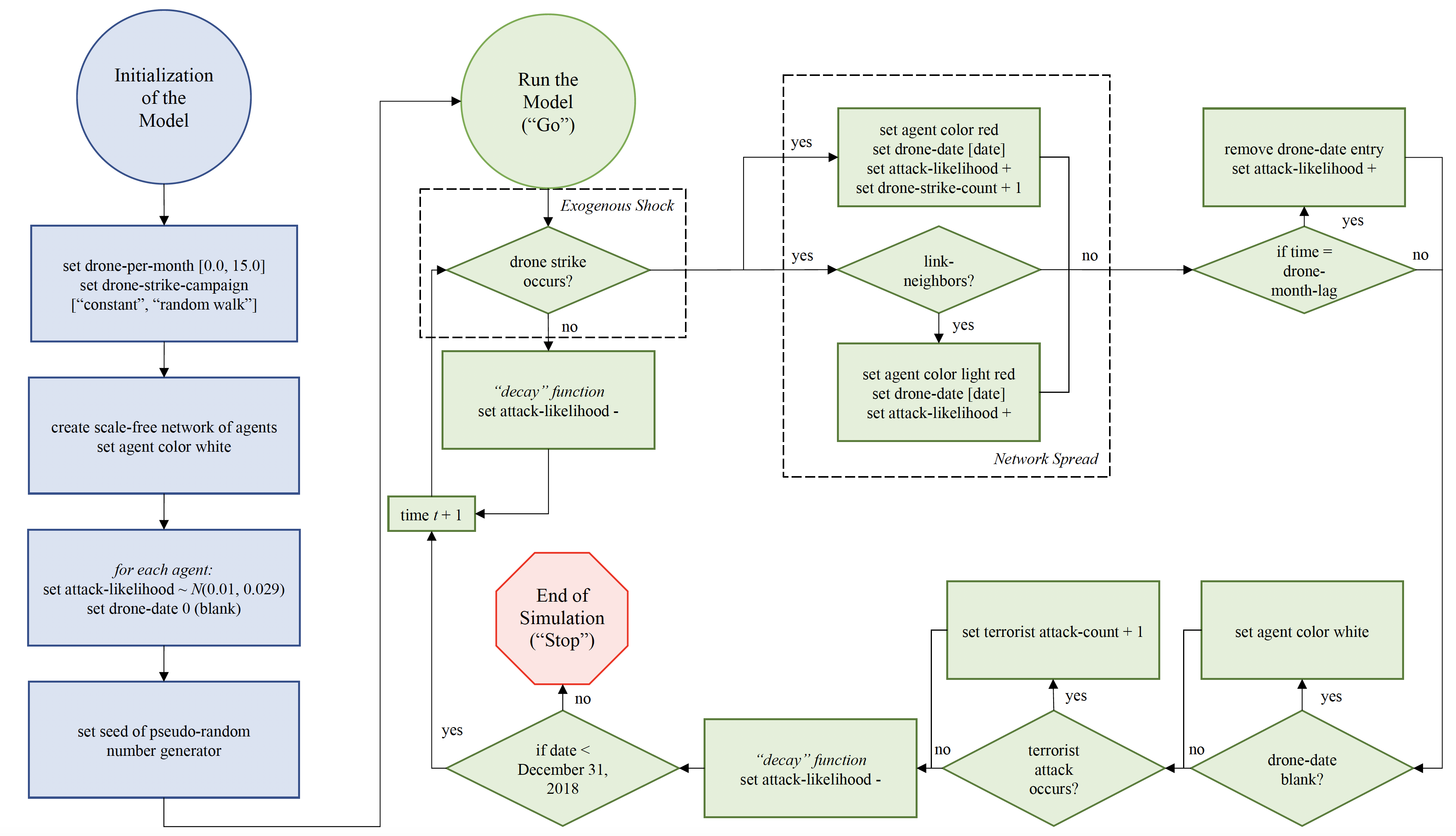
The employment of drone strikes has been ongoing and the public continues to
debate their perceived benefits. A question that persists is whether drone strikes contribute to an increase in radicalization. This paper presents a data-driven approach to
explore the relationship between drone strikes conducted in Pakistan and subsequent
responses, often in the form of terrorist attacks carried out by those in the communities targeted by these particular counter terrorism measures. Our exploration and
analysis of news reports which discussed drone strikes and radicalization suggest
that government-sanctioned drone strikes in Pakistan appear to drive terrorist events
with a distributed lag that can be determined analytically. We leverage news reports
to inform and calibrate an agent-based model grounded in radicalization and opinion
dynamics theory. This enabled us to simulate terrorist attacks that approximated the
rate and magnitude observed in Pakistan from 2007 through 2018. We argue that
this research effort advances the field of radicalization and lays the foundation for
further work in the area of data-driven modeling and drone strikes.
Pakistan radicalization model’s graphical user interface. From left to right: model input param- eters, the agents’ social network and resulting model outputs
The agent-based model flow diagram.
Terrorist attacks simulated by Pakistan radicalization model qualitatively agree with real-world system.
Full Reference:
Shapiro, B. and Crooks, A.T. (2022) Drone Strikes and Radicalization: An Exploration Utilizing Agent-Based Modeling and Data Applied to Pakistan, Computational and Mathematical Organization Theory. Available at https://doi.org/10.1007/s10588-022-09364-1. (pdf)