Just a short post that say that Linda See and myself have a new editorial in Environment and Planning B: Urban Analytics and City Scienceentitled " Leveraging Street Level Imagery for Urban Planning." While in the in the past we have written about street view imagery and how there are initiatives like KartaView (previously named OpenStreetView and OpenStreetCam) and Mapillary which allow for the collection of volunteered street view imagery (VSVI) using just smartphones. But we have not really delved much into how such initiatives could be used to assist assist urban planning (e.,g. change detection, augmented reality (AR) and urban navigation). If this sounds of interest, please feel free to check out our editorial here.
Exploring urban change in Buffalo, New York with Google Street View in October 2020 and the same location in the 2007 inset.
To show the utility of this method we also present three simple applications (e.g., a disease , a disaster and a traffic model) which utilize different parts of this synthetic population but are all geographically explicit and use networks in some shape or form. If this sounds of interest, below you can read the abstract from the paper, along with seeing some of the figures from our methodology and example applications. While at the bottom of the post we provide the full citation and a link to the paper. The paper itself also has links to actual code that generates the synthetic population and the resulting datasets and models (code: https://bit.ly/SynPopABM; source and resulting synthetic population data: https://osf.io/3vsaj/)
.
Abstract:
Geographically-explicit simulations have become crucial in understanding cities and are playing an important role in urban science. One such approach is that of agent-based modeling which allows us to explore how agents interact with the environment and each other (e.g., social networks), and how through such interactions aggregate patterns emerge (e.g., disease outbreaks, traffic jams). While the use of agent-based modeling has grown, one challenge remains, that of creating realistic, geographically-explicit, synthetic populations which incorporate social networks. To address this challenge, this paper presents a novel method to create a synthetic population which incorporates social networks using the New York Metro Area as a test area. To demonstrate the generalizability of our synthetic population method and data to initialize models, three different types of agent-based models are introduced to explore a variety of urban problems: traffic, disaster response, and the spread of disease. These use cases not only demonstrate how our geographically-explicit synthetic population can be easily utilized for initializing agent populations which can explore a variety of urban problems, but also show how social networks can be integrated into such populations and large-scale simulations.
Keywords: Synthetic Population Generation, Agent-Based Modeling, New York, Traffic Dynamics, Disease, Disaster
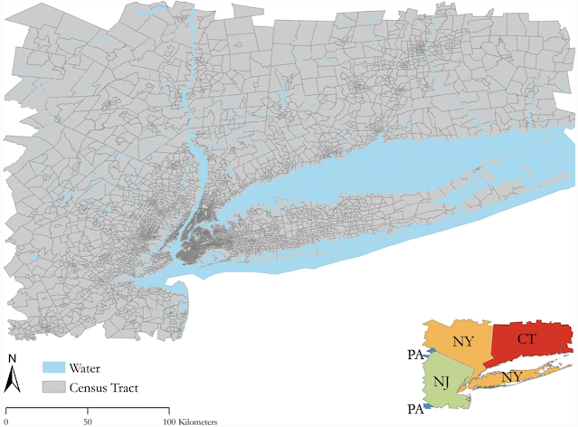
Study Area
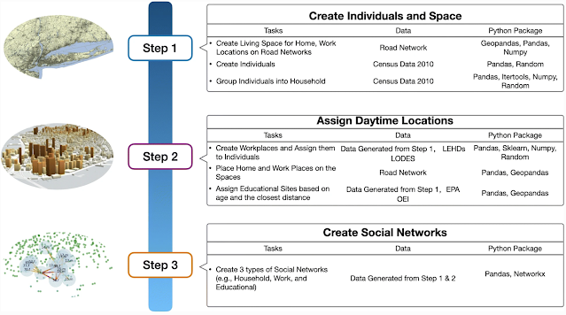
Workflow for Generation of Synthetic Population and Networks
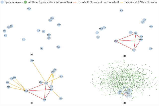
Creation of Social Networks: (a) Selected Population; (b) Creation of a Household Network; (c) Creation of Work and Educational Networks for each Member of the Household; (d) The Household, its Networks within the Full Census Tract
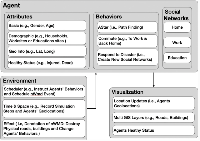
Model Component Structure of Population Respond to Disaster event
Agents’ Health Status After 1 Minute of the Disaster Event
Full Reference:
Jiang, N., Crooks, A.T., Kavak, H., Burger, A. and Kennedy, W.G. (2022), A Method to Create a Synthetic Population with Social Networks for Geographically Explicit Agent-Based Models, Computational Urban Science, 2:7. Available at https://doi.org/10.1007/s43762-022-00034-1
While our book "Agent-based Modelling and Geographical Information Systems" has a lot of details and examples about how to use GIS data within NetLogo (see https://github.com/abmgis/abmgis), as I was preparing for my course this semester entitled "Spatial Simulation" I thought I would develop a more detailed tutorial on how to use vector data to build a segregation model in NetLogo. The model itself is inspired by Schelling's model of segregation, but unlike the regular cell versions which are commonly used as examples here the cells are polygons which are based on census boundaries of Washington DC. The movie below gives a sense of what it looks like when completed.
We introduce the Urban Life agent-based simulation used by the Ground Truth program to capture the innate needs of a human-like population and explore how such needs shape social constructs such as friendship and wealth. Urban Life is a spatially explicit model to explore how urban form impacts agents’ daily patterns of life. By meeting up at places agents form social networks, which in turn affect the places the agents visit. In our model, location and co-location affect all levels of decision making as agents prefer to visit nearby places. Co-location is necessary (but not sufficient) to connect agents in the social network. The Urban Life model was used in the Ground Truth program as a virtual world testbed to produce data in a setting in which the underlying ground truth was explicitly known. Data was provided to research teams to test and validate Human Domain research methods to an extent previously impossible. This paper summarizes our Urban Life model’s design and simulation along with a description of how it was used to test the ability of Human Domain research teams to predict future states and to prescribe changes to the simulation to achieve desired outcomes in our simulated world.
Our generated maps colored based on different aggregation levels.
A screenshot of the graphical user interface from a representative model run. Top-Left: The spatial network and agents. Bottom left: Simulation parameters that can be specified prior to simulation start. Top-middle: the social network. Bottom-middle: Summary statistics of the simulation during tun-time such as friendship. Right: Profiles of recreational sites.
Screenshot of the epidemic simulator depicting the French Quarter, New Orleans, LA, USA.
Full Reference:
Züfle, A., Wenk, C., Pfoser, D., Crooks, A.T., Kavak, H., Kim, J-S. and Jin, H. (2021), Urban Life: A Model of People and Places, Computational and Mathematical Organization Theory. Available at https://doi.org/10.1007/s10588-021-09348-7 (pdf)
With more and more people living in urban areas and the current COVID pandemic, human mobility within cities has changed. With this change there is a a growing debate about what it would take to make cities more accessible. For example, what would it take for the inhabitants of cities be able to access most of their daily essentials (e.g., shopping, work, education, entertainment) within 15 minutes, commuting from their own doorstep either via walking, cycling, or other modes of transportation (e.g., bus, rail)?
With progressively increased people living in cities, and lately
the global COVID-19 outbreak, human mobility within cities
has changed. Coinciding with this change, is the recent uptake
of the ‘15-Minute City’ idea in urban planning around the world.
One of the hallmarks of this idea is to create a high quality of
life within a city via an acceptable travel distance (i.e., 15
minutes). However, a definitive benchmark for defining a ‘15-
Minute City’ has yet to be agreed upon due to the
heterogeneous character of urban morphologies worldwide.
To shed light on this issue, we develop an agent-based model
named ‘D-FMCities’ utilizing realistic street networks and
points-of-interest, in this instance the borough of Queens in
New York City as a test case. Through our modeling we grow
diverse communities from the bottom up and estimate the size
of such local communities to delineate 15-minute cities. Our
findings suggest that the model could be helpful to detect the
flexibility of defining the extent of a ‘15-minute city’ and
consequently support uncovering the underlying factors that
may affect its various definitions and diverse sizes throughout
the world.
Keywords: 15-minute city, Agent-based modelling, Local
communities, Street networks, Point-of-interests,
COVID-19.
Model Demo:
Full Reference:
Chen, Q and Crooks, A.T. (2021). Delineating a ‘15-Minute City’: An Agent-based Modeling Approach to Estimate the Size of Local Communities. In GeoSim '21: Proceedings of the 4th ACM SIGSPATIAL International Workshop on GeoSpatial Simulation, November 2, 2021, Beijing, China, pp 29-37. (PDF)