In this paper we introduce a method for studying urban shrinkage by constructing multi-scale spatial structures based on urban network connectivity which we call gravity-networked spatial interaction zones-based spatial panel modeling or GSIZs-Spanel for short. We demonstrate this method by exploring the spatial processes and scopes of past urban shrinkage in Detroit between 2000 and 2020. If this sounds of interest, below you can read the abstract to the paper, along with the conceptual design of GSIZs-Spanel modeling framework and some of our results. While at the bottom of the post you can find the full referece and link to the paper.
Abstract:
This study introduces a new modeling paradigm called gravity-networked spatial interaction zones-based spatial panel modeling (GSIZs-Spanel). Using Detroit as a case study, this paper investigates urban shrinkage by integrating shrinkage driving factors, their regional interactions, networks of cities, spatial processes, and longitudinal dynamics. Results suggest that high minority population concentration and persistent poverty are the primary factors impacting Detroit’s inner-city shrinkage. Demographics, economics, and development practices affect shrinkage in suburbs and surrounding cities. Shrinkage spreads outwards like waves; different juxtapositions of driving factors affect shrinkage resilience; spillover effects are particularly vibrant at 25–50 GSIZs; rightsizing is a rational strategy, but it failed to work alone. Integrating spatial planning of driving factors, land uses, spillover effects, rightsizing strategy, and regional collaboration among federal, regional, and local organizations could moderate urban decline. GSIZs-Spanel, which was developed here, could be applied in any U.S. city or other global city.
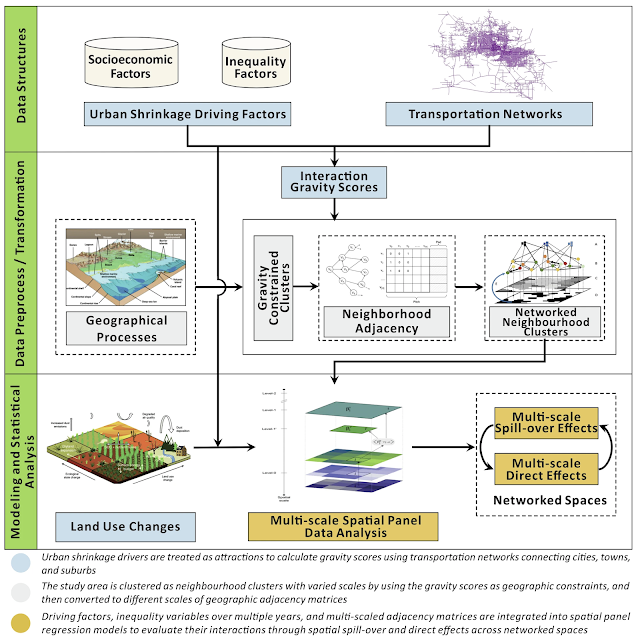 |
| The conceptual design of GSIZs-Spanel modeling framework. |
 |
| Patterns of spillover effects of the Spanel models at the 5-incremental spatial clusters. (a: Spatial processes of urban shrinkage. b: Spatial patterns of vacancy severity.) |
 |
| Spillover effects of the Spanel models at the 5-incremental spatial clusters |
Full Reference:
Meng X., Xie, Y., Crooks, A.T., Wu J., Khan-Welsh, H. and Zen, S. (2025), Examining spatial expansion and stemming strategies of urban shrinkage: evidence from Detroit, USA, npj Urban Sustainability, 5: 52. Available at https://doi.org/10.1038/s42949-025-00245-5 (pdf)


No comments:
Post a Comment